| Home > All By Location regional map > Pittsburgh West > Portal Bridge at Point State Park | |||
|
|
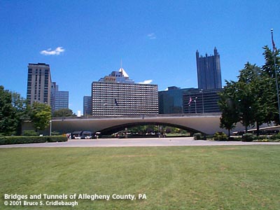
View east toward downtown 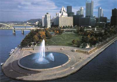
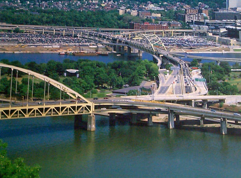
1994 postcard view; 2001 calendar photo More detail photos OFFICIAL NAME: Portal Bridge OTHER DESIGNATION: LOCATION: Pittsburgh USGS 7.5" Topo Quad - UTM Coordinates: Pittsburgh West - Zone 17; 0584 4477 CARRIES: Interstate 279 - two lanes each direction; ramps on deck total 8 lanes wide northern ramps connect: to/from I-279 via Fort Duquesne Bridge; Fort Duquesne Blvd; 10th Street Bypass southern ramps connect: to/from I-279, US22 and US30 West via Fort Pitt Bridge; I-376, US22 and US30 west via Fort Pitt Blvd BETWEEN: -- Fort Pitt Bridge and Fort Duquesne Bridge CROSSES: -- Pedestrian access to Point State Park. Pedestrian arch bridge over reflecting pool is located below Portal Bridge. TYPE OF CONSTRUCTION / DESIGN: reinforced concrete arch 3 vault LENGTH OF MAIN SPAN: 182 ft TOTAL LENGTH (including longest elevated ramp): -- HEIGHT OF DECK: 25 ft YEAR ERECTED / ENGINEER: 1961-63, George S. Richardson, engineer Charles and Edward Stotz, architects Ralph E. Griswold, landscape architect Don McNeil, traffic engineer reconstructed 1999 PennDOT, current owner ADDITIONAL INFO: A discussion of the Portal Bridge necessarily involves the planning and construction of the whole of Point State Park. A very thorough chronicle may be found in "The Shaping of the Point: Pittsburgh's Renaissance Park" by Robert C. Alberts. In October 1918, fifteen prominent Pittsburgh businessmen organized the Citizens' Committee on a City Plan for Pittsburgh and appointed Fredrick Bigger, executive secretary. This organization, later renamed the Municpal Planning Commission, began to work on ways to improve downtown and specifically the Point area, which was covered by Pennsylvania Railroad and Wabash Railroad terminals and yards in addition to a large complex of Exposition Buildings. The Municipal Art Commission, formed in 1913, had been guiding the architectural and asthetic quality of various public works projects. But in spite of the many projects which were completed through the 1920s and into the 1930s, no comprehensive plan for improvements had been carried out. Various organizations promoted their vision for upgrading the Point area, including a small park wedged between the abutments of the Point and Manchester Bridges or a 1930s plan to honor George Rogers Clark at the Point. More sweeping plans began to propose the clearing of the lower Point in favor of a landscaped park. All of these early plans were crafted on the assumption that the two old bridges at the apex would be retained. The 1915 Manchester Bridge, it was theorized, could be removed from its piers and re-erected upstream, but it was suffering from deterioration and would need to be replaced in time. To echo the curved upper chord design of the Manchester Bridge, the 1927 Point Bridge had been constructed as an arching inverted cantilever. This made it impossible to move. These assumptions continued late into the park planning and as late as 1945, when it was finally determined to remove the bridges from the point of the triangle. Renderings from that time show a relocated Manchester Bridge across from a Fort Pitt Bridge as it was ultimately built. With the Depression, the Municpal Planning Commission closed in 1933. In May 1936, a short while after Pittsburgh's greatest flood, the Planning Commission was revived. Once again Fredrick Bigger was involved as techincal consultant. With Howard Heinz, president, and Wallace Richards, planner and manager of the federal government housing project at Greenbelt, MD, as executive director the organization began to look for funding for a major park plan. The plan was originally assumed to be destined to become a National Park Service facility and funding sources were to include the Public Works Administration, Work Progress Administration, and National Park Service. The NPS guidelines required that the original historic structures of Fort Pitt and Fort Duquesne be accurately reconstructed in their original locations. This would have covered the entire park area leaving no room for the needed traffic improvements. With the political contributions of Richard King Mellon and Mayor David L. Lawrence, the plan evolved into a state park. This allowed more flexibility for working all of the historical, recreational, landscaping, and traffic planning elements into a more balanced plan. they also pushed for changes in the eminent domain laws -- which although allowing much greater lattitude in consolidating properties into the Gateway Center project also under development later were to be used in Allegheny Center and East Liberty and still later by Mayor Thomas Murphy in the Marketplace at Fifth and Forbes redevelopment proposal. As part of his 1939 proposal, New York's parks and traffic planner Robert Moses wrote: "...we must say that the relics and historical association (of the Point) should be regarded as comparatively unimportant in the solution of present and future city planning problems. Construction of the Point and Manchester Bridges at the site of old Fort Pitt has determined that traffic rather than history must be the decisive factor in the reconstruction of the apex of the Pittsburgh triangle and the establishment of Point Park." Ralph E. Griswold, landscape architect, Charles M. Stotz, architect and architectural historian had been appointed to continue the development of the Point Park design. By this time, the Gateway Center project had shown much progress and was to include a site for a new State Office Building. The competing requirements (historical, recreational, landscaping, and traffic planning) led to the addition of George S. Richardson, bridge engineer, and Don McNeil, traffic engineer. A breakthrough came in 1945 when it was finally agreed that there would be no truly successful design while the Point and Manchester Bridges remained in place. Even after that old assumption had been eliminated, various designs for two bridges at the base of the triangle were tried with limited success. Federal highway guidelines called for an 800 foot radius on interchange ramps; even with a 200 foot radius the ramps would have cut through the current location of the State Office Building. The Pittsburgh Railways Company operated 718 trolleys on eight routes through the Point area. Any new bridges would require local traffic and streetcar access between the narrow banks along the river. Many designs were set out but included very tight looping ramps. Even a double-decked bridge with two-way express lanes above and two-way local and rail traffic below failed to satisfy the needs. In 1949, the struggling Pittsburgh Railways Company was finally forced by the U.S. District Court to issue a report that revealed plans to replace the streetcars with busses. This changed and simplified everything. Acting on the suggestion of engineer Mike Rapuano, Richardson developed the scheme which is in place on the Fort Pitt and Fort Duquense Bridges today: double-deck with one way traffic on each deck. This further simplified the ramps needed to route the traffic and allowed the highway crossing the Point Park area to be grouped into a single band. The interchange design and street connections were complete by 1953. But the planning model omitted how the downtown business area would access the park. The planners' vision all along had been to open the Point as a sweeping open vista to the West to remind visitors of Pittsburgh's historic role as the Gateway to the West. Charles and Edward Stotz, architects, were faced with the challenge of creating an inviting opening in an eight-lane wall of highway nearly 200 feet long and 25 feet high. A rectangular opening would look like a "keyhole slot turned sideways"; a wider opening would require more piers like a railroad trestle. A typical arch, a culvert which obscured the view westward. Gordon Bunshaft, architect with Skidmore, Owings and Merrill, suggested a very long, flat arch and new technology in prestressed reinforcing rods in concrete would make it possible, if difficult. The Stotz brothers designed "a flat concrete rib arch with a span of 182 feet, a clearance height of less than 23 feet, (and) a crest of hardly more than 2 feet thick...The portal had an interior hollow shell with three curved vaults, each 160 feet long, arching across and between four heavily reinforced ribs 40 feet apart, the ribs taking part in the overall arch action." The three-hinged arch was designed to be flexible -- especially in response to temperature variation which would be exaggerated due to the arch's flat shape. Four pairs of twelve-ton inward-facing hinges are mounted in enormous concrete blocks. These are tied "together by seven-five tendons of eighteen-strand steel wire running underground below the portal -- so tightly that they stretched about eleven inches under tension. All this replaced the keystone in the normal arch." The design was so complex that a five-foot long model was submitted to the Pennsylvania Department of Highways and Richardson in lieu of plan drawings. Once prepared, the structural plans were given to a ship hull contractor to create the timber forms for the concrete vaults. An article in the Engineering News-Record, November 1, 1962, gives more technical details and mentions Eugene Freyssinet who designed the post-tensioning system and personally surpervised its use on this project. The design below the highway was completed with the addition of a gently arching, forty-foot wide, pedestrian bridge over a shallow reflecting pool. The small bridge under the bridge also supports service vehicles up to ten tons. The floor of the pool is covered with rounded glacial stones, each about eight inches across, arranged in concentric rings and forming a fish scale pattern. Large concrete "buckets" hide the three pairs of lights which shine upwards, filling the ceiling vaults. From the highway, the view of downtown as well as toward the Point fountain remains clear. Often as motorists drive near such places, there are many obstructions: fences, Jersey barriers, buildings and so on. Driving though doesn't match the experience from the park visitor, but it is better than most other places encroached upon by traffic. And for the visitor on foot (bicycles are not allowed), the extreme rush of traffic just 25 feet overhead is hardly noticed, if at all. The open lawn is framed by the Portal Bridge and stands of reintroduced native varieties of trees along each river. And the apex with its monumental fountain is a destination hard to resist. An early concern for planners was "would anyone care to walk so far to visit the park?" With all the other elements in place, the Portal exchanged a barrier for a magnetic passageway. With Independence Day, the Three Rivers Regatta, the Three Rivers Arts Festival and the many other events held in the park -- in addition to joggers, sightseers, sunbathers and others -- the Park is more successful than those who began the process in the 1910's would have dreamed. People love the park -- and that is the whole point. view page - Fort Pitt Bridge view page - Fort Duquense Bridge FIELD CHECKED: 06-Jul-2001 INFO SOURCES: field check; Alberts, "The Shaping of the Point" Submit info or inquiry - share some facts or ask a question. Introduction -- Nearby Structures Page created: Last modified: 27-Jul-2001 |
View Larger Map 
| |
| copyright: © Bruce S. Cridlebaugh 1999-2008 All Rights Reserved | |||