| Home > All By Location regional map > Pittsburgh West > Manchester Bridge 1915-1970 | |||
|
|
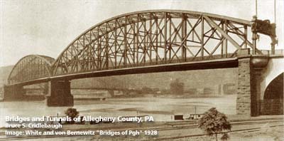
1928 photo 
Elevation drawing looking downstream More detail photos OFFICIAL NAME: North Side Point Bridge OTHER DESIGNATION: Manchester Bridge LOCATION: Pittsburgh USGS 7.5" Topo Quad - UTM Coordinates: Pittsburgh West - Zone 17; 0584 4477 CARRIED: motor vehicles, street railway BETWEEN: -- Allegheny Av on right descending bank of Allegheny River -- Water St on left descending bank of Allegheny River CROSSED: -- Allegheny River at mile 0 TYPE OF CONSTRUCTION / DESIGN: subdivided Pratt through truss, 2 spans LENGTH OF MAIN SPAN: 2 spans, 531 ft each TOTAL LENGTH (including longest elevated ramp): 2840 ft (Point approach, 913 ft; river spans, 1062 ft total; Allegheny approach, 865 ft) HEIGHT OF DECK: 70 ft YEAR ERECTED / ENGINEER: 1915; removed 1970 ADDITIONAL INFO: The northern pier was left in place after the demolition of the bridge in 1970. It was intended to serve as an observation deck in the riverside park along the Allegheny River. The park, later named Roberto Clemente Park, was built as part of the construction of Three Rivers Stadium. The Manchester bridge portal sculptures by Charles Keck were to be mounted on the old stone-faced pier, but the project was never completed. The sculptures have been stored at the Old Post Office (Children's Museum) on the North Side since. The plan may be resurrected as part of the 2000 construction of the Pittsburgh Steelers football stadium adjacent the park. More Information from Historic American Engineering Record. More Information about bridge construction in Point State Park. FIELD CHECKED: INFO SOURCES: Submit info or inquiry - share some facts or ask a question. Introduction -- Nearby Structures Page created: Last modified: 07-Dec-2000 |
View Larger Map 
| |
| copyright: © Bruce S. Cridlebaugh 1999-2008 All Rights Reserved | |||