| Home > All By Location regional map > Braddock > Greensburg Pike over Turtle Creek | |||
|
|
View northwest from First St toward town of Turtle Creek 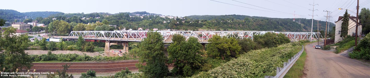
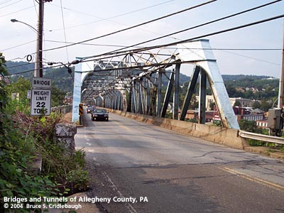
View northeast from First St, North Versailles More detail photos OFFICIAL NAME: OTHER DESIGNATION: Greensburg Pike Bridge brad599-17 LOCATION: North Versailles - Turtle Creek USGS 7.5" Topo Quad - UTM Coordinates: Braddock - Zone 17; 0599 4472 CARRIES: -- Greenburg Pike (former Lincoln Hwy) BETWEEN: -- First St (North Versailles) -- Monroeville Av, Penn Av, Airbrake Av (Turtle Creek) CROSSES: -- Norfolk Southern RR (former Conrail, PRR mainline); Turtle Creek; abandoned rail spurs (interworks railroad) to Westinghouse Airbrake factories TYPE OF CONSTRUCTION / DESIGN: four Pratt through truss spans, three riveted girder spans LENGTH OF MAIN SPAN: TOTAL LENGTH (including longest elevated ramp): 845 ft HEIGHT OF DECK: YEAR ERECTED / ENGINEER: 1925, Allegheny County ADDITIONAL INFO: The portion of Greensburg Pike (Pittsburgh and Greensburg Turnpike) between Circleville (Westmoreland Co.) and Churchill linked two important early roads across Pennsylvania. There were two branches of the Raystown Path from Bedford: Greensburg Pike follows the southern route; General John Forbes used the northern branch (Frankstown Rd) in 1758 when he took over the site of what would become Pittsburgh. General Edward Braddock followed the Nemacolin's Path before meeting his defeat as he advanced toward the Forks of the Ohio in 1755. (Braddock's Road diverted south from Greensburg Pike / Lincoln Hwy at Circleville.) Many Indian paths followed the ridgelines to avoid the swampy lowlands; later roads followed and improved these paths. Venturing westward toward Pittsburgh, the path of what would become Greensburg Pike avoided the "defiles of Turtle Creek" by tracing the high line to the south of the Great Valley -- one of the local nicknames for the Turtle Creek Valley. In East McKeesport, at one of the highest hilltops in Allegheny County, the path was forced to descend into the valley as the hillsides got only more severe approaching the outflow of the creek into the Monongahela River. A mile-long, nine percent grade took the path to a crossing of the creek (the location of this bridge). Crossing the bottomland and continuing westward, the path made another steep ascent to follow another ridgeline from Turtle Creek to another hilltop between Wilkinsburg and Churchill. On Lime Hill (Churchill), another of the highest hilltops in Allegheny County, the Greensburg Pike and the Northern Turnpike met. This site has been noted as the location of one of several places called "Bullock Pens." Local historians say the pens were an important source of livestock for the military forces in early Pittsburgh. The Forbes and Braddock Roads had been built as military roads. The routes suited their purposes, but over time, the State Road modified the route from the east. An 1806 act authorized a new turnpike to be constructed, with commisioners in the various counties along its route. Dividing the routes into section made fundraising by stock subscription easier. An 1811 act authorized the commonwealth to provide $300,000 to the company which could raise $150,000 in stock. A competition developed between the southern route (which included the Greensburg Pike) and what would become the Northern Turnpike. The rivalry delayed the construction of both, with the Northern Pike opening locally in 1819 -- after the southern route. The section of the southern route known as The Pittsburgh and Greensburg Turnpike was promoted by Westmoreland County Associate Justice Colonel John Irwin. In 1814 the road was opened "past the Colonel's home on Brush Hill Road in Irwin, as well as his brother's house on Verdant Drive" and westward to Turtle Creek. By 1820, the toll road was expanded to reach from Philadelphia (roughly along the line of today's US30 - Lincoln Highway) to Pittsburgh along Penn Av. Dates found in various sources indicate that the construction in Western Pennsylvania progressed from west to east. William Wilkins, judge and namesake of the nearby town and township, was president of the Pittsburgh and Greensburg Turnpike Company. Managers included other prominent citizens: William Carver, William B. Foster (father of songwriter Stephen Collins Foster), William Fullerton, William Hindman, James Irwin, Abraham Horbach, Dunning McNair (part of early Wilkinsburg was once McNairstown), Jacob Negley Jr., Tobias Painter, Ephraim Pentland (newspaper publisher and politician), Robert Patterson and Thomas Simpson. ===== "Westinghouse Valley," Anthony Lewis, 1910: In 1857, Mr. Joseph B. Hezlep, was advised by a Pittsburgh merchant to locate at Turtle Creek, and go into business there. The friend had great hopes for the future of that place and as one of its drawing qualities, said that it was the center for seven country roads all centering in Turtle Creek village, and that it would be a good place for a merchandise business. "Pittsburgh: An Urban Portrait," Franklin Toker, 1986: The Westinghouse Electric Corp. East Pittsburgh Works extends about two miles along Turtle Creek, north of the Westinghouse bridge. George Westinghouse achieved the first practical application of alternating current for electric power transmission in 1886 with a demonstration wire between the Golden Triangle and Lawrenceville. Realizing what an immense demand his system would create for generators and electric machinery, Westinghouse purchased 500 acres of land in the Turtle Creek Valley in 1887 as the site for a giant factory complex, but fierce opposition from Edison and the partisans of direct current electricity forced him to stay his hand for six years. In 1893 Westinghouse scored two decisive triumphs over Edison by supplying AC electricity to the Chicago Fair and exploiting the water power of Niagara Falls: the next year the East Pittsburgh works opened to national and international acclaim. The plant employed 20,000 workers at its peak, many of whom lived in the small homes that were built for them by the Westinghouse land company in the nearby valleys and mesa tops of East Pittsburgh, Turtle Creek, Trafford, and Wilmerding. An impressive group of these wooden homes and boardinghouses stands north of the plant on Brown Avenue (Route 130 North), toward Churchill. From the plant came the world's first electric locomotive, first regular radio broadcast (on Pittsburgh's KDKA), and first electronic television camera. Much of the old complex was clad in a metal skin in 1957 (one manufacturing aisle was seven stories high and three football fields in length), but Thomas Rodd's French Renaissance administration building, where Westinghouse worked, is still intact. ===== A factor in Westinghouse's selection of the Turtle Creek Valley was its prominent location on the Pennsylvania Railroad mainline between Pittsburgh and Philadelphia. The rail line had been completed from Pittsburgh to Turtle Creek in December 1851. A final section completed in November, 1852, opened the line to Philadelphia. The borough of Turle Creek was incorporated in 1892. It included perhaps the oldest post office in this part of the county. By 1910, it was reported that 102 daily trains stopped at either East Pittsburgh, Turtle Creek or Wilmerding. The four Westinghouse companies employed as many as 25,000. An aerial map of the town of Turtle Creek, drawn by Thaddeus M. Fowler in 1897, shows the PRR had expanded to five lines. Greensburg Pike crossed the railroad and creek on a Howe truss near the passenger rail station which stood south of the stream. This older bridge was set a an angle which matched the street grid of the valley, thereby creating a sharp turn for traffic descending from East McKeesport. At the northern end of the bridge, stone ramps split in opposite directions to meet Penn Avenue (Airbrake Av) near Eleventh St. The older bridge was placed for the convenience of the railroad: a simple structure without skew crossed the PRR mainline railroad, the stream, and the inter-works railroad at a right angle. Curb cuts and paving remain in place, giving clues to the location of the older bridge -- the predecessor to the 1925 structure. The Hopkins map shows the older bridge and an indication of the roadway prior to that bridge's construction. The first location probably included an at-grade crossing adjacent to the passenger station; the older bridge would have been built to eliminate the dangerous crossing. [1903 Hopkins map] In 1913, the Lincoln Highway Association was established, plotting a coast-to-coast all-weather road across the United States. The route through Pennsylvania followed today's US30. The original course followed Greensburg Pike into Turtle Creek and Electric Avenue out of East Pittsburgh westward toward Pittsburgh. [postcard, Lincoln Hwy, Turtle Creek, c1930] This path included a mile-long, nine-percent hill leading to the old bridge over the stream and railroad at Turtle Creek. To enter the bridge, motorists had to negotiate a sharp, dangerous turn at each end of the bridge. Once in the valley, the then bustling traffic and activity from the town and surrounding factories created major delays. Some reported an hour travel time in crossing the two miles through the valley. By 1925, the Lincoln Highway and other named roads were displaced by a federally-established numbering system of US Highways. What had been the Lincoln Highway became US30. Noting the travel difficulties through Turtle Creek, Allegheny County began to make plans for relief. Working in conjunction with the Pennsylvania Railroad, a new multi-span, through-truss bridge was opened in 1925 to carry Greensburg Pike over the stream and tracks. By incorporating a series of skewed trusses, the dangerous angles were decreased. The new bridge touched down Monroeville Av, approximately two blocks west of the northern end of the previous bridge. This also made a more logical connection to local streets and their regional connecting roads. Soon after, the county began construction of a bypass to carry US30 over the Turtle Creek Valley. The George Westinghouse Bridge, the largest concrete arch bridge when completed in 1932, was a $1.75 million part of the $4.4 million Lincoln Highway re-routing project. Below the Greensburg Pike Bridge, the Turtle Creek Flood Control Project was completed in 1967 by the US Army Corps of Engineers. Sloping concrete walls contain the stream from Wilmerding downstream past East Pittsburgh. Below the Westinghouse Bridge in East Pittsburgh, a movable vertical gate dam (no longer operational) was designed to prevent back flooding from the Monongahela River. ===== from the PennDOT Historic Bridges Survey: The 7 span, 845'-long bridge built in 1925 is composed of 4 rivet connected Pratt thru truss spans (166', 192', 192', 140') and 3 steel deck girder approach spans (52', 52', 42'). The truss spans have built up members of standard steel sections. A cantilevered sidewalk with standard county pipe railing is on the south side. The bridge is supported on concrete abutments, built-up steel bents for the approach spans, and concrete piers for the main spans. Safety shape concrete barriers enclosing the roadway are from a 1978 deck replacement project. The bridge is a late example of its type and design that is not individually distinguished by its technology. The bridge's significance is in association with the development of the PHMC-determined eligible PRR Main Line. It dates from the line's period of significance and it is associated with efforts to improve the safety and efficiency of the line by improving grade crossings. The bridge was built as a joint project of the railroad and the county. FIELD CHECKED: 28-Aug-2004 INFO SOURCES: field check; Fowler aerial map, 1897; Hopkins map, 1903; Westinghouse Valley," Anthony Lewis, 1910; "Pittsburgh: An Urban Portrait," Franklin Toker; PennDOT Historic Bridges Survey; turtlecreekwatershed.org Submit info or inquiry - share some facts or ask a question. Introduction -- Nearby Structures Page created: Last modified: 07-Jul-2005 |
View Larger Map View Larger Map 
| |
| copyright: © Bruce S. Cridlebaugh 1999-2008 All Rights Reserved | |||