| Home > All By Location regional map > Braddock > George Westinghouse Memorial Bridge | |||||||||
|
|
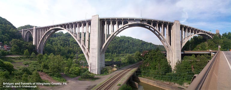
Panoramic view west from PA130 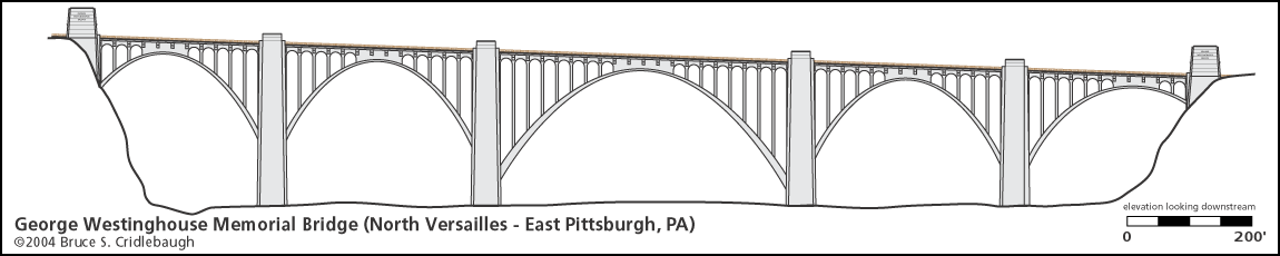
More detail photos OFFICIAL NAME: George Westinghouse Memorial Bridge OTHER DESIGNATION: Westinghouse Bridge LOCATION: East Pittsburgh - North Versailles USGS 7.5" Topo Quad - UTM Coordinates: Braddock - Zone 17; 0598 4471 CARRIES: motor vehicles [US30, Lincoln Highway], 4 lanes BETWEEN: -- East Pittsburgh -- North Versailles CROSSES: -- (north to south) Union RR mainline; Braddock Av [Tri-Boro Expwy]; Union RR branch; 2 tracks Norfolk Southern RR [PRR mainline]; Turtle Creek; Norfolk Southern RR [PRR Port Perry Branch and former yard]; Elder St TYPE OF CONSTRUCTION / DESIGN: open spandrel concrete arch LENGTH OF MAIN SPAN: 460 ft central span, 153.5 ft rise TOTAL LENGTH (including longest elevated ramp): 1,598 ft, 5 spans HEIGHT OF DECK: approx 240 ft YEAR ERECTED / ENGINEER: 1929-1932, County of Allegheny Vernon R. Covell, chief engineer; George S. Richardson and A.D. Nutter, engineers; Booth and Flinn Co., contractor ADDITIONAL INFO: Opened in 1932 to carry the Lincoln Highway US30 over the entrance to the Turtle Creek Valley, The bridge was a $1.75 million part of a $4.4 million Lincoln Highway re-routing project. This bridge provided a bypass to a dangerous, often congested portion of the important highway. Despite a 1925 bridge which helped straighten a sharp curve at the bottom of the Greensburg Pike hill entering Turtle Creek, the original route descended to the bottom of the valley, through the then busy town of Turtle Creek, past the Westinghouse Electric plant, and back up the other wall of the valley as it headed west toward Pittsburgh. This bridge cut nearly two miles and most of an hour out of the valley crossing. Hailed as one of the most impressive combinations of structure and setting, the bridge features five reinforced concrete parabolic arches with open spandrels and two longitudinal ribs. The structure bounds almost one-third of a mile across and 240 feet above the Turtle Creek Valley as it opens into the Monongahela Valley. The central arch, once the longest concrete arch span in the world, spans 460 feet with a rise of 153.5 feet. The other four spans have an arch rise of 96'-6". According to the Historic American Engineering Record document, the lengths of each span (from North Versailles to East Pittsburgh): 196'-4", 295'-0", 460'-0", 295'-0", 277'-0". The HAER document quotes the Engineering News-Record concerning the construction of the arches: Steel-truss centering was used in all of the arch spans, so fabricated that it could be made to conform to the intrados of arches of different span lengths and so planned that the two arches at either end of the bridge would be first completed and then all of the centering assembled to support the 460-ft. span. The majesty of the bridge structure is lost to those who merely cross its deck, although the presentation of impressive views of the valley's industrial heritage and the westward traveller's first glimpse of the building tops of downtown Pittsburgh make it difficult not to stray one's gaze laterally. As if to offer further consolation, but more to cap this structure as an historical monument, four pylons at the entrances have 10' x 18' art deco granite reliefs by Frank Vittor. With a relief of up to 8 inches, the chiseled scenes depict the development of the Turtle Creek Valley including the defeat of the British General Braddock by the French and Indians in 1755; the steel industry (USS Edgar Thompson Works is just west of the bridge, built on the site of Braddock's Defeat); electricity (George Westinghouse's main manufacturing complex is below the bridge to the east and extends up the Turtle Creek Valley), and in honor of Mr. Westinghouse's varied contributions to invention and industry. Stanley Roush, noted as the architect for the City of Pittsburgh on many projects including the Smithfield St Bridge portals, was the architect for the pylons and the reliefs were finished after the bridge (1934-36). They also include escutcheons with the coat of arms seal of Allegheny County. An $11.3 million in renovation in 1982-83 included a modified deck with a wider roadway and Jersey barriers. Fortunately, the sidewalks were retained on both sides. The bridge was reopened in October 1983. Below the bridge stands the former home of the now-dissolved Westinghouse Electric Corporation. The site was the company's home since 1895 and the site of the first commercial radio broadcast in 1920 (which evolved into KDKA). In 1989, the complex of buildings was turned over to the Regional Industrial Development Corporation of Southwestern Pennsylvania to be developed into an industrial-business park. "RIDC is a private, non-profit economic development corporation established in 1955 by the business, corporate, governmental and labor leaders of that time. (Their) mission is to provide diversified economic development services." The site became Keystone Commons. More info about RIDC projects (Western PA Brownfields Center): Keystone Commons (PDF) view page - Historic American Engineering Record document PA-446
Northwest pylon: George Westinghouse
Northeast pylon: Electricity
Southwest pylon: Turtle Creek Valley history
Southeast pylon: Steel
On the southwest pylon:
FIELD CHECKED: 30-May-2001 INFO SOURCES: field check; Kidney "Pittsburgh's Bridges"; Gay and Evert "Discovering Pittsburgh's Sculpture"; Tribune-Review "East Pittsburgh building a bridge to tomorrow", July 28, 1996; HAER. Submit info or inquiry - share some facts or ask a question. Introduction -- Nearby Structures Page created: Last modified: 04-Jun-2001 |
View Larger Map View Larger Map View Larger Map 
| |||||||
| copyright: © Bruce S. Cridlebaugh 1999-2008 All Rights Reserved | |||||||||