| Home > All By Location regional map > Braddock > PRR Port Perry Bridge | |||
|
|
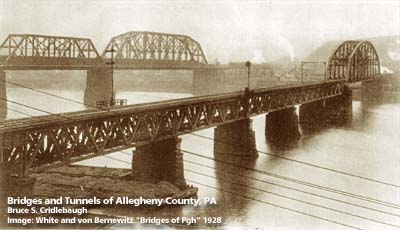
1928 view 
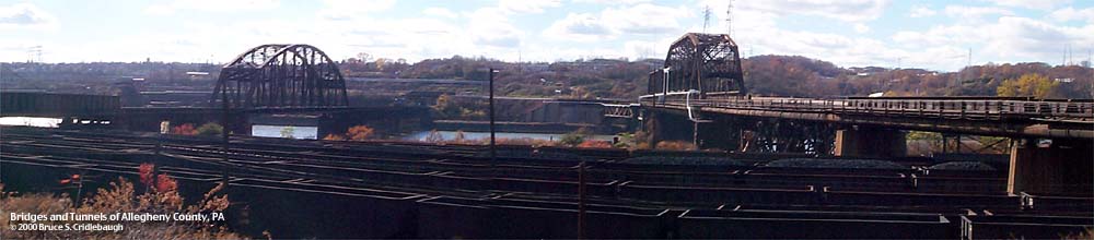
View south from Port Perry (URR bridge to right) Main information page OFFICIAL NAME: OTHER DESIGNATION: PRR Port Perry Bridge brad597-26 LOCATION: Duquesne - North Versailles USGS 7.5" Topo Quad - UTM Coordinates: Braddock - Zone 17; 0597 4471 CARRIES: Norfolk Southern railroad BETWEEN: -- right descending bank of Monongahela River (Port Perry, North Versailles) -- left descending bank of Monongahela River (Duquesne) CROSSES: -- (north to south) Union RR; CSX RR; Monongahela River at mile 11.6; Union RR TYPE OF CONSTRUCTION / DESIGN: Steel Parker/Pratt through truss; steel Warren deck trusses LENGTH OF MAIN SPAN: 409.5 ft (393.0 ft clearance) TOTAL LENGTH (including longest elevated ramp): 1,496 ft HEIGHT OF DECK: 45.6 ft, vertical clearance, at center line of channel span Lock and Dam No. 2, Braddock, normal pool level 718.7 ft YEAR ERECTED / ENGINEER: 1902-03; Pennsylvania Railroad; William H. Brown, chief engineer replaced 1872 structure and reused original piers ADDITIONAL INFO: Industry increased and Pittsburgh was booming at the end of the 19th Century. Traffic on the various divisions of the Pennsylvania Railroad became more and more congested. Three major projects were constructed to allow through trains to bypass downtown: the 1877 Port Perry bridge and tunnel joined the Pittsburgh and Monongahela Divisions near Duquesne on the Monongahela River; the Ohio Connecting Railroad bridge first crossed the Ohio River at Brunot's Island in 1890; and the Brilliant Branch in 1904, with its Allegheny River crossing near Highland Park, linked the Pittsburgh Division mainline at East Liberty to the Conemaugh Divison. Proving their value, both the Port Perry and Brunot's Island crossings would be replaced with stronger structures. The Port Perry Branch connected the Pennsylvania Railroad at Brinton (Bessemer Junction) on Turtle Creek to the Pittsburgh, Virginia & Charleston Railway (later PRR Monongahela Division) on the left descending bank of the Monongahela River. All of these lines are now part of the Conrail properties acquired by the Norfolk Southern in 1989. Hopkins maps show the tunnel as double-tracked in 1900. Historic American Engineering Record reports the bridge across the Monongahela River as having been double-tracked. Both are now single-track. The town of Port Perry has been completely obliterated by the crossing and recrossing of railroads there. Today the Norfolk Southern, CSX [B&O] and the Union Railroad fill every usable bit of ground where a town of over 3,000 people once stood. view page - More history of the town of Port Perry view page - More history of the Edgar Thomson Works view page - Port Perry Tunnel . . . from the Historic American Engineering Record (HAER): Now an unpopulated bend on the Monongahela River, Port Perry is an important junction in the Pittsburgh rail network, being the crossroads of four railroads. The original Port Perry Bridge was built from 1872-77 by the Pennsylvania Railroad (PRR) to connect its Main Line to the Pittsburgh, Virginia and Charleston Railway (PV&C). Formed in 1867, the PV&C was built along the west bank of the Monongahela River, from the southside of Pittsburgh to the coal fields of the mid-Monongahela Valley, ending at West Brownsville, PA. From the beginning, the PV&C was an important coal road, carrying coal and coke from mine to mill site. The PV&C was formally leased to the PRR in 1879, was fully acquired in 1905, and operated as part of the PRR's Monongahela Division. Today the route is part of Conrail's Pittsburgh Division. [acquired by Norfolk Southern 1989] Although only four miles long, the Port Perry Branch provided an important link between the PV&C, which connected with the Panhandle Division for westbound traffic, and the Pennsylvania Main Line at East Pittsburgh. This connection allowed through freight to by-pass the congestion and limitations created by traveling the Main Line through the city of Pittsburgh. In 1902 the U.S. Army Corps of Engineers approved the permit for a new bridge at Port Perry. Set upon the original 1872 piers, the new bridge, a pin-connected, Parker through truss with Warren deck trusses, was designed by the Pennsylvania Railroad Engineering Division, under the supervision of William H. Brown, Chief Engineer. Originally double tracked, the bridge is composed of 11 sections with a total span of 1,496 ft. However, the 45.6 ft height above the normal pool level is one of the lowest on the upper Monongahela. With the planned changes in the Monongahela navigation system, the bridge's clearance will be too low, requiring modification. However, the Port Perry Bridge and the route of the original PV&C Railway remain a crucial link in Conrail's network. Conrail's new emphasis on running taller, double-stack container trains make the Port Perry Bridge a vital detour around the low clearances in the city of Pittsburgh. . . . from the U.S. Army Corps of Engineers: CONRAIL BRIDGE RELOCATION FACT SHEET LOCKS AND DAMS 2, 3 AND 4 MONONGAHELA RIVER NAVIGATION (LOWER MON) PROJECT March 1999 The low steel of span 7 of the Conrail Bridge, Port Perry Branch (Conrail Bridge) located in Pool 2 at river mile 11.7 is currently 45.6 feet above the navigation channel. The pool change associated with the Lower Mon Project will raise navigable waters in existing Pool 2 five (5) feet, thus reducing the vertical clearance of the bridge to 40.6 feet, making it 1.9 feet lower than the U.S. Coast Guard required vertical guide clearance of 42.5 feet. The Lower Mon Project authorization provides for the adjustment of the Conrail Bridge using project funds and monies to be provided by the bridge owner. Concept studies and preliminary designs completed to date by the Corps and Conrail have identified various options to adjust the bridge to provide the additional 2.6 feet of clearance. One option preferred by the Corps would replace span 7 (407-foot span between piers 7 and 8) over the navigation channel with a new span constructed of higher strength steel and a modified truss design to achieve the required vertical clearance without changing the rail grades. This option can be achieved through various plans to either rehabilitate or replace Piers 7 and 8 to handle the additional loads of the new span. However, the waterways industry and the USCG object to any plan that would reduce the horizontal opening between Piers 7 and 8 based on concerns for the safe navigation of upbound and downbound tows using Locks 2 immediately downstream. The rehabilitation of existing Pier 8 with a proposed encapsulation of the existing pier would reduce the clearance between the CSX main track No. 2 and the existing bridge Pier 8 below the 9'-0" required. This would require the relocation of two tracks of the CSX railroad which parallel the river and cross under the Conrail Bridge. A total of 1500 track feet of CSX rail would have to relocated to a new alignment landward. The proposed track shift would be done with minimum disturbance to CSX daily traffic. Also, a temporary 4-gain signal and communications pole would have to relocated during any rehabilitation of Pier 8. Also, the bridge adjustment would involve the replacement of a USX steel pipeline attached to the upstream side of the existing Conrail Bridge which conveys nitrogen from the Edgar Thompson Works to other mills in the valley. A critical design consideration of any bridge adjustment plan is the concern by Conrail that rail service not be disrupted for longer than 24 hours. The Pittsburgh District is now preparing to engage the services of an expert Architect-Engineering firm with expertise in railroad design to complete the Plans and Specifications for the bridge alteration. FIELD CHECKED: 10-May-2000 INFO SOURCES: USACE Monongahela River Nav. Charts; USACE website; Historic American Engineering Record Submit info or inquiry - share some facts or ask a question. Introduction -- Nearby Structures Page created: Last modified: 20-Nov-2001 |
View Larger Map 
| |
| copyright: © Bruce S. Cridlebaugh 1999-2008 All Rights Reserved | |||