| Home > All By Location regional map > Pittsburgh West > Fort Pitt Tunnel | |||
|
|
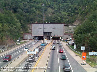
Western portal More detail photos OFFICIAL NAME: Fort Pitt Tunnel OTHER DESIGNATION: LOCATION: Pittsburgh USGS 7.5" Topo Quad - UTM Coordinates: Pittsburgh West - Zone 17; 0583 4476 CARRIES: Interstate 279, US22, US30 [Penn Lincoln Parkway West] two lanes each bore; emergency walkway on inner wall BETWEEN: -- Fort Pitt Bridge over the Monongahela River -- Penn Lincoln Parkway West near Saw Mill Run (formerly Shalersville) UNDER: Mount Washington (formerly Coal Hill), Duquesne Heights TYPE OF CONSTRUCTION / DESIGN: two bores, flat plenum ceiling; concrete with ceramic tile lining; 7 cross passages; downtown portal for westbound traffic is lower than eastbound TOTAL LENGTH: 3,614 ft OTHER DIMENSIONS: 13ft 6 in posted vertical clearance 28 ft wide (est) YEAR OPENED / ENGINEER: 1957-1960 (opened September 1, 1960), PA Dept of Highways PennDOT, current owner ADDITIONAL INFO: Famous as the "best way to enter an American city," motorists travelling from the West on I-279 are given no visual cues regarding their nearness to downtown Pittsburgh as they enter the Fort Pitt Tunnel. Emerging from the portal, the Golden Triangle suddenly bursts into view framed by the yellow crossbracing of the arch of the Fort Pitt Bridge over the Monongahela River. Portions of the Parkway West were opened in October 1951, but traffic followed the West End Bypass around the unfinished tunnels. July 11, 1954, contracts were awarded for the basic design of the Fort Pitt Tunnels. The construction contracts totalling just over $10 million for the downtown section for the Parkway west of Grant St and the Fort Pitt Bridge were awarded in January, 1956. The Fort Pitt Tunnels groundbreaking ceremony was held April 17, 1957. And the drilling began August 28. Estimated cost for the new tunnels was $17 million. In 1958, downtown was finally linked to the Parkway East at Grant St. On March 31, Mayor David L. Lawrence and Governor George L. Leader activated an explosive charge which created and opening in the top arc of the Fort Pitt Tunnels' north portal above West Carson St. One year and one month later, the Fort Pitt Bridge opened -- leading only to and from West Carson St. The Fort Pitt Tunnels were opened on September 1, 1960, as the last link in the Penn Lincoln Parkway. The downtown portals are vertically offset to allow traffic to mesh with the stacked deck of the Fort Pitt Bridge. Traffic into downtown crosses the bridge on the upper deck. Outbound traffic uses the lower bridge deck and passes into a tunnel portal which is about 30 ft lower in elevation. The outbound bore gradually rises to meet the elevation of its neighbor so that the West End portals are at the same elevation. The Fort Pitt Tunnels are similar in design to the Squirrel Hill Tunnels on the Parkway East and the Lehigh Tunnels on the Northeast Extension of the PA Turnpike which were constructed at about the same time. Of the highway tunnels in Allegheny County, the Fort Pitt Tunnels (3,614 ft) are third in length behind the Liberty Tubes (5,889 ft) and the Squirrel Hill Tunnels (4,225 ft) on the Parkway East. PennDOT lists the following facts: 1,788 light fixtures with 3,576 bulbs; 10 ventilation fans; 187,200 sq ft tiled surface to wash; cross-section area 392 ft; serving nearly 107,000 vehicles per day view page - More history of the Fort Pitt Tunnels and the Parkway. Pittsburgh's west suburban traffic is measured from the Fort Tunnel. Morning and evening rush hours each form their jam from this location: typically stretching westward to Greentree or Carnegie in the morning and eastward to Grant St and onto the Fort Duquesne Bridge in the evening. The granite facing of the service buildings at each portal was repaired in 1993-94 as the first phase of a major rehabilitation project scheduled to be completed by September 2003. Radio repeaters were installed (1999-2000) to allow motorists to receive AM and FM broadcasts uninterrupted. An updated and enhanced overheight warning system was installed in 2000 at the West End entrance; the ceiling at the inbound entrance has been scarred many times. The lower deck of the bridge and outbound tunnel will be closed for rehab in 2002; inbound / upper deck work will be performed in 2003. FIELD CHECKED: INFO SOURCES: Lorant: "Pittsburgh: The Story of an American City"; Pittsburgh Post-Gazette Submit info or inquiry - share some facts or ask a question. Introduction -- Nearby Structures Page created: Last modified: 10-Sep-2001 |
View Larger Map < 
| |
| copyright: © Bruce S. Cridlebaugh 1999-2008 All Rights Reserved | |||