| Home > All By Location regional map > Pittsburgh West > West End Circle elevated lanes over West Carson St | |||
|
|
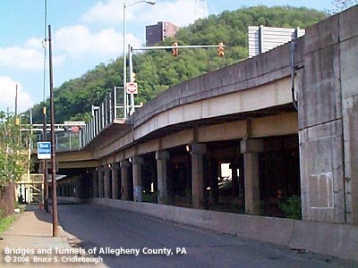
Elevated lanes above West Carson St More detail photos OFFICIAL NAME: OTHER DESIGNATION: West End Circle elevated lanes above West Carson St pghw LOCATION: Pittsburgh USGS 7.5" Topo Quad - UTM Coordinates: Pittsburgh West - Zone 17; 0582 4477 CARRIES: US19; PA51 BETWEEN: -- West End Bridge [US19] over Ohio River -- West Carson St [PA51 north of intersection] -- West Carson St [PA837 south of intersection] -- South Main St [PA60] connection to West End Bypass [US19, PA51] -- Steuben St CROSSES: -- West Carson St; Saw Mill Run TYPE OF CONSTRUCTION / DESIGN: Deck girder LENGTH OF MAIN SPAN: TOTAL LENGTH (including longest elevated ramp): HEIGHT OF DECK: YEAR ERECTED / ENGINEER: 1931, Allegheny County & PA Dept of Highways? 1991, PennDOT ADDITIONAL INFO: view page - Other structures in the West End Valley FIELD CHECKED: 10-May-2004 INFO SOURCES: field check Submit info or inquiry - share some facts or ask a question. Introduction -- Nearby Structures Page created: Last modified: 13-Jul-2004 |
View Larger Map View Larger Map 
| |
| copyright: © Bruce S. Cridlebaugh 1999-2008 All Rights Reserved | |||