| Home > All By Location regional map > Pittsburgh West > West Carson St over Saw Mill Run | |||
|
|
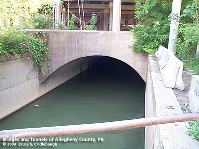
View south (upstream) from WSB RR/PLE RR bridge OFFICIAL NAME: OTHER DESIGNATION: West Carson St over Saw Mill Run; West End Circle LOCATION: Pittsburgh USGS 7.5" Topo Quad - UTM Coordinates: Pittsburgh West - Zone 17; 0582 4477 CARRIES: West Carson St [PA837]; piers for elevated lanes of West End Circle; Norfolk Southern Railroad [former PRR] BETWEEN: -- below West End Circle CROSSES: -- Saw Mill Run TYPE OF CONSTRUCTION / DESIGN: Closed spandrel concrete arch (culvert) LENGTH OF MAIN SPAN: 36 ft TOTAL LENGTH (including longest elevated ramp): HEIGHT OF DECK: YEAR ERECTED / ENGINEER: c1915; extended 1931, Allegheny County ADDITIONAL INFO: from the PennDOT Historic Bridges survey: The bridge carries a dirt access road and support piers for West Carson Street and the West End Circle over a small stream. view page - Other structures in the West End Valley FIELD CHECKED: 10-May-2004 INFO SOURCES: field check Submit info or inquiry - share some facts or ask a question. Introduction -- Nearby Structures Page created: Last modified: 13-Jul-2004 |
View Larger Map 
| |
| copyright: © Bruce S. Cridlebaugh 1999-2008 All Rights Reserved | |||