| Home > All By Location regional map > Pittsburgh West > OCRR Bridge at Brunot Island | |||
|
|
View downstream from Neville Island 
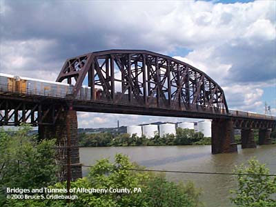
Elevation drawing looking downstream More detail photos OFFICIAL NAME: OTHER DESIGNATION: OCRR Bridge at Brunot Island, back channel of Ohio River pghw580-9 LOCATION: Pittsburgh USGS 7.5" Topo Quad - UTM Coordinates: Pittsburgh West - Zone 17; 0580 4479 CARRIES: railroad, two tracks [Ohio Connecting Railroad, PRR, Conrail, NS RR] BETWEEN: -- CROSSES: -- Ohio River back channel at Mile 2.3 -- CSX RR; PA837, PA51, West Carson St TYPE OF CONSTRUCTION / DESIGN: steel through truss LENGTH OF MAIN SPAN: 406 ft (est) TOTAL LENGTH (including longest elevated ramp): HEIGHT OF DECK: 67.9 ft Emsworth Dam normal pool level 710 ft YEAR ERECTED / ENGINEER: 1915 ADDITIONAL INFO: The retaining wall of the southern abutment is constructed of massive stone blocks. Many of these blocks show the marks made by stonecutters -- a symbolic signature -- which tradition says were used as proof of their work for payment. Similar marks may be found on the abutment stones of the Panther Hollow Bridge in Schenley Park, Oakland. view page - OCRR Bridge at Brunot Island, main channel of Ohio River FIELD CHECKED: 23-Jun-2000 INFO SOURCES: USACE Ohio River Nav. Charts Submit info or inquiry - share some facts or ask a question. Introduction -- Nearby Structures Page created: Last modified: 12-Oct-2000 |
View Larger Map View Larger Map 
| |
| copyright: © Bruce S. Cridlebaugh 1999-2008 All Rights Reserved | |||