| Home > All By Location regional map > Pittsbugh East > Laurel St, NS RR and Edgewood Av over Parkway East | |||
|
|
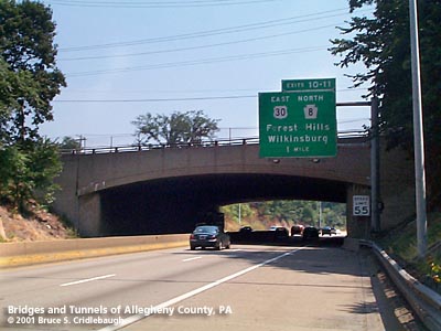
View eastbound on I-376 More detail photos OFFICIAL NAME: 736-5B, 990+00 OTHER DESIGNATION: Conrail Bridge over Parkway East Edgewood Av over Parkway East Pennsylvania RR Bridge Conrail #2 LOCATION: Edgewood USGS 7.5" Topo Quad - UTM Coordinates: Pittsburgh East - Zone 17; 0594 4475 CARRIES: [west to east] -- Laurel St (former entrance to Union Switch and Signal) -- Port Authority East Busway extension -- Norfolk Southern (former PRR and Conrail) mainline between Pittsburgh and Philadelphia -- Edgewood Av BETWEEN: -- Elm St -- Oakview Av CROSSES: -- Parkway East [I-376, US22, US30], four lanes divided TYPE OF CONSTRUCTION / DESIGN: [west to east] -- Laurel St: reinforced concrete rigid frame segmental arch -- Railroad: simple girder [one span] -- Railroad: riveted steel rigid frame spans [5 adjacent spans] -- Edgewood Av: reinforced concrete rigid frame segmental arch LENGTH OF MAIN SPAN: [west to east] -- Laurel St: 74 ft -- Railroad: 81 ft -- Railroad: 81 ft -- Edgewood Av: 73 ft TOTAL LENGTH (including longest elevated ramp): HEIGHT OF DECK: YEAR ERECTED / ENGINEER: 1949, PA Dept of Highways ADDITIONAL INFO: At first, this structure appears to be a single bridge -- and since its width is greater than its span some maps have even noted it as a tunnel. Closer examination suggests it is three spans: a steel structure sandwiched between two concrete spans. But this, in fact, eight separate structures built side-by-side. Records state this was one of the earliest parts of the Parkway project with construction beginning in November, 1947, and completing in August, 1949. The highway grading in this section was not started until January, 1950, apparently needing to await the completion of this complex of structures in Edgewood Borough and the Brinton Av bridge. The construction by John F. Casey Company of Pittsburgh was complicated by the requirement of maintaining railroad, trolley and motor vehicle traffic which crossed here. The Pennsylvania RR mainline between Pittsburgh and Philadelphia was laid here in 1854 and by the 1940s included five tracks with a possible expansion to a sixth. Only two tracks were allowed to be taken out of service at any time. Today, only two tracks remain active for the Norfolk Southern railroad. Laurel St once provided motor vehicle access and one railroad siding to the Union Switch and Signal complex; the factory has been replaced by the Edgewood Towne Centre shopping plaza and the street has been closed. Edgewood Av once carried two lanes of traffic, two trolley tracks and a five-foot sidewalk. The trolley tracks are gone, but the street remains an important link between Edgewood and Swissvale. The Laurel St and Edgewood Av structures are reinforced concrete rigid frame segmental arch spans. They stand on either side of the railroad spans. The railroad structure consists of five steel haunched rigid frame spans -- one for each Pennsylvania RR track -- and one simple steel girder span built in the event the railroad required a sixth track. The construction of the railroad bridges took two railroad tracks out of service at a time. Interlocking sheet piling was installed around the site and excavation of the railroad embankment was carried out within the sheet piling. In 2000 construction began on the Port Authority East Busway extension. The Martin Luther King East Busway was completed from downtown Pittsburgh at Liberty Av to Rebecca St in Wilkinsburg in 1983. The 2.3 mile extension to be completed in 2002 to Rankin uses part of the former PRR right-of-way adjacent to Laurel St. The 1904 G. M. Hopkins plat map shows the NY&CGC Co (New York & Cleveland Gas Coal Co.) railroad operating a spur line from the PRR mainline along what would become the Parkway route to the east. This line extended to the location of the Brinton Rd bridge. Another plate from the map book shows the spur served the Enterprise Brick and Stone Co, which included an incline plane from Chalmers St in Swissvale and a mine (also with an incline plane) which pierced the hillside to the north of the current Parkway route. FIELD CHECKED: 02-Aug-2001 INFO SOURCES: field check; 1953 PA Dept of Highway report; Port Authority of Allegheny County Submit info or inquiry - share some facts or ask a question. Introduction -- Nearby Structures Page created: Last modified: 07-Aug-2001 |
View Larger Map View Larger Map View Larger Map View Larger Map 
| |
| copyright: © Bruce S. Cridlebaugh 1999-2008 All Rights Reserved | |||