| Home > All By Location regional map > Pittsbugh East > Bloomfield Bridge 1986 | |||
|
|
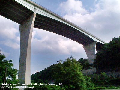
View east More detail photos OFFICIAL NAME: Bloomfield Bridge OTHER DESIGNATION: pghe568-3 LOCATION: Pittsburgh USGS 7.5" Topo Quad - UTM Coordinates: Pittsburgh East - Zone 17; 0588 4479 CARRIES: Four lanes; sidewalk on upstream side BETWEEN: -- Liberty Av at Main St (Bloomfield) -- Bigelow Blvd [PA380, S.R.0400] at Blessing St (Polish Hill) CROSSES: -- (north to south): Ewing St; Dean Field; Sassafras St (Neville, St, Lorrigan St); CSX RR (Pittsburgh Junction RR); Two Mile Run (covered); Norfolk Southern RR (former PRR); Port Authority Busway; Melwood Av TYPE OF CONSTRUCTION / DESIGN: steel haunched welded girder LENGTH OF MAIN SPAN: TOTAL LENGTH (including longest elevated ramp): 1,535 ft (total of nine spans) HEIGHT OF DECK: 150 ft est YEAR ERECTED / ENGINEER: 1986, City of Pittsburgh Louis R. Gaetano, director, Department of Public Works Gannett Fleming, engineers ADDITIONAL INFO: view page - Bloomfield Bridge 1914-1980 The previous bridge was permanently closed in May 1978. Demolition was delayed by court rulings until July 1980. Further "red tape" stalled the start of construction until Spring of 1982. Steel was placed for the new spans in late 1984. The new bridge opened November 1, 1986. The Gannett Fleming website states: "Placed along the same alignment as the original deteriorated structure, the new bridge incorporates four lanes with a barrier median and a five-foot sidewalk. The nine-span bridge reaches a total length of 1,535 feet between abutment bearings. This project received the 'Outstanding New Bridge Design 1986' Award given by the Association for Bridge Construction and Design and the AISC '1989 Prize Award for Medium Span High Clearance.' " FIELD CHECKED: 13-Jun-2004 INFO SOURCES: field check; Barry Chad, Bidwell oral history of Clyde Wright, Carnegie Library of Pittsburgh; Gannett Fleming Submit info or inquiry - share some facts or ask a question. Introduction -- Nearby Structures Page created: 28-Jun-2004 Last modified: 2012-09-05, 28-Jun-2004 |
View Larger Map View Larger Map View Larger Map 
| |
| copyright: © Bruce S. Cridlebaugh 1999-2012 All Rights Reserved | |||