| Home > All By Location regional map > Pittsbugh East > Parkway East Int - Glenwood / Oakland | |||
|
|
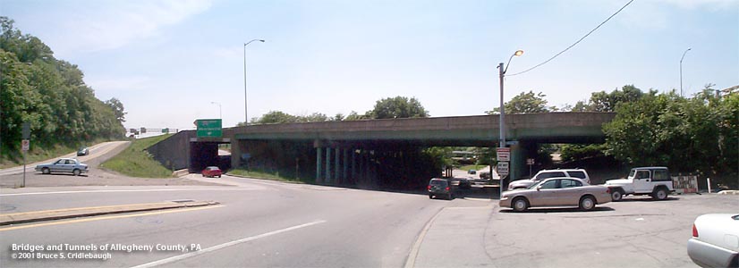
View south on Bates St More detail photos OFFICIAL NAME: Penn Lincoln Parkway East - Interchange 7B - Glenwood PA885 South [mileage-based interchange # 3A] SR8006 Penn Lincoln Parkway East - Interchange 7A - Oakland PA885 North [mileage-based interchange # 3B] SR8006 OTHER DESIGNATION: Bates St exit 763-2B, 770+55 [mainline over Bates St] Parkway East #32 LOCATION: Pittsburgh USGS 7.5" Topo Quad - UTM Coordinates: Pittsburgh East - Zone 17; 0588 4475 CARRIES: -- eastbound entrance to Parkway East [I-376, US22, US30] from Bates St, PA885 -- eastbound exit from Parkway East [I-376, US22, US30] to Bates St, PA885 North [Oakland] -- eastbound exit from Parkway East [I-376, US22, US30] to Bates St, PA885 South [Glenwood] BETWEEN: CROSSES: -- Parkway mainline over Bates St and Eliza Furnace Trail Access -- Glenwood ramp over Hodge St TYPE OF CONSTRUCTION / DESIGN: -- Parkway mainline over Bates St: steel girder with riveted splice plates, girder columns on concrete bent caps, concrete abutments -- Parkway mainline over eastbound entrance ramp: concrete rigid frame tunnel -- Glenwood ramp over Hodge St: steel girder on concrete abutments LENGTH OF MAIN SPAN: -- Parkway mainline over Bates St: 2 side spans of 58 ft, 1 span of 76 ft -- Parkway mainline over eastbound entrance ramp: -- Glenwood ramp over Hodge St: 63 ft TOTAL LENGTH (including longest elevated ramp): - Parkway mainline over Bates St: 196 ft HEIGHT OF DECK: -- Parkway mainline over Bates St: 14 ft (restricted by 11ft-6in clearance of adjacent RR bridge) [96 ft deck width] -- Parkway mainline over eastbound entrance ramp: 14ft-5in posted (clearance at spring line at tunnel exit) -- Glenwood ramp over Hodge St: 13ft-7in posted YEAR ERECTED / ENGINEER: -- Parkway mainline over Bates St: 1952 -- Parkway mainline over eastbound entrance ramp: -- Glenwood ramp over Hodge St: 1953 PA Dept of Highways ADDITIONAL INFO: Built before the onset of standard pattern designs, each of the structures along the Parkway have unique details. At Bates St, the mainline span deck girders are less complicated than the others built along the highway at this time. But the unusual artifact here is the columns which support the continuous span: they are W-shape steel girder set vertically with concrete footers and concrete bent caps. The W-shape girders (also known as stringers) which carry the deck are joined with riveted splice places. Later design specs would call for bolted connections. This section of the Parkway East was constructed between November, 1949 and February, 1953, by B. Perini & Sons, Inc. of Framingham, MA. The company also excavated and lined the Squirrel Hill Tunnel and built the Frazier St Bridge over Four Mile Run. Although the clearance below the mainline bridge is sufficient for most traffic (estimated at over 15ft), the adjacent, former B&O RR bridge which spans Bates St has a posted clearance of only 11ft-6in. In the nearly 90 years that railroad bridge has been in place, the toll of impacts from overheight vehicles has been great. At the intersection of Bates and Hodge streets, a path leads under the western side span of the Parkway mainline. This allows access to the Eliza Furnace Recreation Trail built on the former B&O RR right-of-way. A rehab project in 1981-82 replaced the deck and added Jersey barriers. Painted numbers on mainline girder (10-82, 770+55) and on the Hodge St ramp girder (10-81, 3+41.27) note the year of the update project, and identify the location. The concrete box tunnel which allows eastbound vehicles to pass under the mainline to enter the Parkway shares design features of structures which would be included at the Grant St interchange six years later. This interchange may face some major alterations with the coming of the Mon-Fayette Expressway. The new highway is planned to join the Parkway East near this location with links to Bates St. Bates St is one of the major gateways to Oakland -- famous for medical facilities, universities, museums and Schenley Park. At the head of the Three Mile Run Ravine, an arch bridge once crossed from Halket St to Wilmot St (now the route of Blvd of the Allies) between Zulema St and Bates St That part of the ravine has been substantially filled. excerpt from: "Pittsburgh : a sketch of its early social life / by Charles W. Dahlinger." "The ravine through which a rivulet coursed, called "Three-Mile Run," long sewered over, opened on the Monongahela River, at a point now occupied by the Jones & Laughlin Steel Company's ore-yard, and by the offices of the Eliza Furnace. To-day (1916) there are laid out through the ravine several unpaved hillside streets with narrow board sidewalks, one of which is the lower portion of Halket Street. On the upper edge of the ravine is Bates Street, named for Tarleton Bates. The duel was fought near the Monongahela River...Bates fell at the second shot...and expired in an hour...Bates lay in the ravine which has forever since been haunted with his memory." Tarleton Bates (1755-1806) was prothonotary for Allegheny County and editor of the newspaper "Tree of Liberty" noted for its Democratic sentiment. Ephraim Pentland, editor of "The Commonwealth" and a Republican rival, had been engaged in a published dispute with Bates. Rather than taking legal action, Pentland challenged Bates to a duel, which the latter declined. The challenge was carried to Bates by Thomas Stewart. When Bates published his reasons for declining the duel, he mentioned Stewart, who determined to issue a challenge of his own -- with fatal results for Bates, January 8, 1806. FIELD CHECKED: 31-May-2001 INFO SOURCES: Submit info or inquiry - share some facts or ask a question. Introduction -- Nearby Structures Page created: Last modified: 25-Jul-2001 |
View Larger Map View Larger Map View Larger Map 
| |
| copyright: © Bruce S. Cridlebaugh 1999-2008 All Rights Reserved | |||