| Home > All By Location regional map > Pittsbugh East > Twenty-Eighth Street Bridge over PRR | |||
|
|
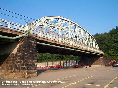
View southeast from Sassafras St More detail photos OFFICIAL NAME: OTHER DESIGNATION: Twenty-Eighth Street Bridge LOCATION: Pittsburgh USGS 7.5" Topo Quad - UTM Coordinates: Pittsburgh East - Zone 17; 0587 4478 CARRIES: 28th St BETWEEN: -- Liberty Av (The Strip) -- Brereton St (Polish Hill) CROSSES: (north to south) -- Port Authority of Allegheny County busway, 2 lanes -- Norfolk Southern RR (former Pennsylvania Railroad), 3 tracks -- Sassafras St (unmarked) -- parking lot TYPE OF CONSTRUCTION / DESIGN: Parker through truss LENGTH OF MAIN SPAN: 202 ft TOTAL LENGTH (including longest elevated ramp): 315 ft HEIGHT OF DECK: YEAR ERECTED / ENGINEER: 1931, City of Pittsburgh replaced previous structure (c1890) on existing stonework ADDITIONAL INFO: from the PennDOT Historic Bridges Survey: The 5 span, 315'-long bridge built in 1931 consists of a 202'-long, rivet-connected Parker thru truss and 4 steel stringer approach spans. The truss has built-up section chords and rolled section verticals and diagonals. It is supported on ashlar piers, dating to a previous bridge, and the approach spans are supported on concrete abutments and piers. The bridge is an undistinguished example of the rivet-connected Parker truss type and design. Examples dating to before 1910 are not uncommon in the state, and later examples such as this have all standard details. According to city records, the bridge was built by the city to improve vehicular traffic flow, rather than by the railroad to improve its operations. It does not have a significant historic association with the development of the PHMC-determined eligible PRR Main Line. The bridge is not historically or technologicaly distinguished by its setting or context. The bridge carries a 2 lane street and 2 sidewalks over 3 active Conrail tracks, a transit authority busway, a city street, and a parking lot. The setting is an area of early 20th century warehouses and late 20th century office complexes that lacks the integrity and cohesiveness of a potential historic district. The railroad is the former Pennsylvania RR Main Line. Two tracks have been removed for the busway. The line has been determined eligible by PHMC (DOE 9/14/93). The 1876 Hopkins map shows the Western Pennsylvania Hospital at the southern end of the bridge, occupying the same area as the current playground and recreation center at Brereton and 30th streets. The Polish Hill neighborhood is labeled as Millwood and Springfield. The Pennsylvania Railroad mainline was operational here beginning December 1851 and through to Philadelphia one year later. The alignment was shifted slightly southward to its current location in 1865. Maps are not clear as to whether 28th Street (PRR milepost 351.82) was an at-grade crossing. The stonework in the approach and piers have stonecutter's marks in many of the blocks. Tradition says these chiseled marks -- a symbolic signature -- were used as proof of their work for payment. Similar marks may be found on the abutment stones of the 1897 Panther Hollow Bridge in Schenley Park, Oakland, and the 1890 Ohio Connecting Railroad Bridge over the Ohio River. They may also help to provide a date for the original bridge. The PRR operated a roundhouse with coaling station, water tanks and other equipment service facilities at 28th Street. FIELD CHECKED: 08-Jun-2004 INFO SOURCES: field check; PennDOT Historic Bridges Survey; "The Pennsy in the Steel City," Kobus & Consoli Submit info or inquiry - share some facts or ask a question. Introduction -- Nearby Structures Page created: Last modified: 18-Jun-2004 |
View Larger Map 
| |
| copyright: © Bruce S. Cridlebaugh 1999-2008 All Rights Reserved | |||