| Home > All By Location regional map > Pittsbugh East > Parkway East Int - Blvd of Allies & Forbes Av | |||
|
|
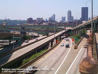
View west from Blvd of the Allies 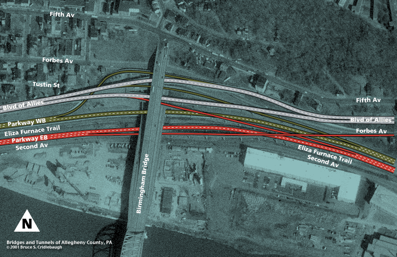
Aerial photo map Photo page 1 Photo page 2 Photo page 3 Photo page 4 Historical images OFFICIAL NAME: Penn Lincoln Parkway East - Interchange 5 - Forbes Av / Oakland [mileage-based interchange # 2A] SR8004 Penn Lincoln Parkway East - Interchange 6 - Blvd of the Allies / Liberty Bridge / I-579 [mileage-based interchange # 2B] SR8004 OTHER DESIGNATION: LOCATION: Pittsburgh USGS 7.5" Topo Quad - UTM Coordinates: Pittsburgh East - Zone 17; 0587 4476 CARRIES: -- eastbound exit from Parkway East [I-376, US22, US30] to Forbes Av eastbound -- eastbound entrance to Parkway East [I-376, US22, US30] from Blvd of Allies eastbound -- westbound exit from Parkway East [I-376, US22, US30] to Blvd of Allies westbound -- westbound entrance to Parkway East [I-376, US22, US30] from Blvd of Allies westbound BETWEEN: CROSSES: -- Parkway East [I-376, US22, US30]; Second Av; Brady St; Birmingham Bridge; Blvd of Allies; Forbes Av TYPE OF CONSTRUCTION / DESIGN: LENGTH OF MAIN SPAN: TOTAL LENGTH (including longest elevated ramp): HEIGHT OF DECK: YEAR ERECTED / ENGINEER: Parkway structures: 1952-1956, PA Dept of Highways Blvd of Allies: 1921 with later modifications ADDITIONAL INFO: Forbes Av has long been an important route -- following a creek valley behind The Bluff down to Suke's Run. In 1910, the Olmstead report recommended that because Forbes Av had become so congested, but was too narrow to widen sufficiently, a new boulevard should be built to connect downtown with Oakland. Monongahela Blvd, immediately renamed the Blvd of the Allies, was completed in 1921 along the cliff edge of The Bluff overlooking the Monongahela River. The Blvd of the Allies once ended where it merged with Forbes Av in Soho. It was extended toward Schenley Park c1930. To carry the Boulevard from the eastern end of The Bluff, a girder viaduct with trussed bents was built to cross the Brady St valley. The long trestle of the northern approach Brady St Bridge met Forbes Av here; today there is a small part of a stone abutment showing from this trestle. This area is a collection of artifacts from many projects. The limestone block pavers from an earlier, now unused, part of Forbes Av still show streetcar tracks. Railings from 1921, the 1930s, 1952 and the 1980s give clues to the changes. When the Penn Lincoln Parkway East was being built, conflicts with the relocation of the Baltimore and Ohio RR tracks and yard along Second Av caused delays in completing the highway from Brady St to downtown. The first ramps in this interchange were completed in 1952 and for the next six years, until the Grant St interchange was opened, this would be the western end of the Parkway East. Ramps from the Blvd of the Allies to the westbound Parkway (1954) and from the eastbound Parkway to Forbes Av (1956) would add to the complexity of the stack. In 1976, the Birmingham Bridge approach ramps -- a replacement for the Brady St Bridge -- would be threaded through the legs of the crossing trestles. The decks of the Parkway ramps were rehabbed in 1985. Concrete was poured on corrugrated steel panels which are visible through the original floor beams. The aluminum railings were replaced with Jersey barriers. In 2000, the Eliza Furnace recreational trail was opened on the right-of-way of the B&O RR. It leads between the opposing lanes of the Parkway. FIELD CHECKED: 09-May-2001 INFO SOURCES: Submit info or inquiry - share some facts or ask a question. Introduction -- Nearby Structures Page created: Last modified: 10-May-2001 |
View Larger Map View Larger Map View Larger Map 
| |
| copyright: © Bruce S. Cridlebaugh 1999-2008 All Rights Reserved | |||