| Home > All By Location regional map > Pittsbugh East > 31st Street Bridge | ||||||||||||||||||||
|
|
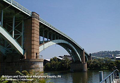
Main channel span of Allegheny River (downstream right) 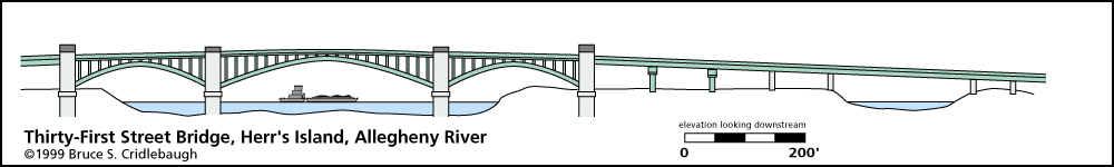
Elevation drawing looking downstream More detail photos OFFICIAL NAME: Thirty-First Street Bridge, Number Six Allegheny River OTHER DESIGNATION: 31st Street Bridge pghe586-18 LOCATION: Pittsburgh USGS 7.5" Topo Quad - UTM Coordinates: Pittsburgh East - Zone 17; 0586 4479 CARRIES: 31st St (SR2122) 2 lanes undivided - motor vehicles pedestrian sidewalk on both upstream and downstream sides of deck BETWEEN: -- River Av and PA28 [East Ohio St, Alexander H. Lindsay Highway] on right descending bank of Allegheny River -- 31st St, intersecting with Penn Av, on left descending bank of Allegheny River CROSSES: -- (RDB to LDB) Conrail (NS) Conemaugh Division - 3 tracks; intersection with River Av; BO industrial railroad siding; North Shore bike/hike trail access; Allegheny River back channel; Herr's Island (Washington's Landing); Allegheny River at mile 2.5; BO industrial railroad 2 tracks; 31st St access to City of Pittsburgh Tow Pound; PRR industrial railroad; Smallman St; Mullberry Wy TYPE OF CONSTRUCTION / DESIGN: Steel deck arch - riveted plate girder; 3 main spans; open spandrel; 2 ribs; center arch 3-hinged; two side arches 2-hinged Approach spans: steel plate girder simple spans and suspended span over Allegheny River back channel (7 at north approach, including 1 steel pony plate girder span over Conemaugh Div RR; 16 at south approach, including pony girder spans over Smallman St and factory entrance) Concrete piers and abutments; channel piers include ashlar courses at their base; 2 northern approach bents steel, 5 concrete; all southern approach bents steel Granite caps on arch piers LENGTH OF MAIN SPAN: 360 ft clear at center span; 2 other arches approx. 180 ft each TOTAL LENGTH (including longest elevated ramp): 2681 ft HEIGHT OF DECK: 72.6 ft low steel clearance at spring line of arches 180 ft clearance at center of arch Emsworth Dam normal pool level 710 ft YEAR ERECTED / ENGINEER: 1927-28 County of Allegheny Vernon R. Covell, County Engineer Stanley L. Roush, Architect PennDOT, current owner ADDITIONAL INFO: The design and general dimensions of this bridge are similar to the Washington Crossing Bridge completed three years earlier at 40th St. At each side of the center arch, the tops of the piers provide a widened section of sidewalk which act a viewing platforms. The outer arch abutment piers rise above the bridge deck to form stone pylons. On each pylon a door/plaque includes the County of Allegheny seal and the following text: The top of each outer pylon is ringed with a carved zig-zag motif. Toward the deck, a pair of eagles face inward on either side of bas relief panels. The southeast and northwest outer piers show George Washington in military uniform on horseback. He is led by a scout, presumably Christopher Gist, on foot who carries a rifle over his shoulder and has one hand raised in greeting. Another man is seated on a low stone facing a campfire. Opposite the fire, an indian with full headdress bends to one knee while offering a pipe to the visitors. Behind him, another indian in full headdress stands, holding a spear and carrying a bow over his shoulder. To the right, another indian gallops away on horseback. More information on Washington's 1753 crossing near Herr's Island can be found on the Washington Crossing Bridge page. The southwest and northeast outer piers depict pioneer farming and early settlement. Seated on the ground, a woman holds her baby close in her arms. A young boy stands behind her pointing at approaching visitors. With them in front of a small farmhouse are a pig and a rooster, while her husband plunges a shovel into the farm ground. Approaching from the right, a long-bearded man leads a double-team of oxen pulling a covered wagon. A woman sits in the drover's seat of the wagon and a dog walks at the side of the front wheel. The steel superstructure is constructed of riveted plate girders. The three main spans are open spandrel 2-hinged arches having 2 ribs. All metal parts of the bridge are painted light green. The approach spans are a series of simple spans using 6 stringers each. The northern approach crosses the back channel of the Allegheny River via a suspended plate girder span. The bridge makes a perpendicular river crossing then turns to align the southern approach with 31st St at the south shore. The ballustrade which runs the length of the bridge includes 15 interlocking metal roman arches between each of the thicker stanchions. This bridge was built a part of the requirement for all Allegheny River bridges to be raised to allow better river navigation. It replaced an earlier structure which was aligned with 30th Street. That 1887 through truss bridge was destroyed by fire July 8,1921. The county erected a temporary cable suspension foot bridge which was used while the present 31st St Bridge was constructed. An informational panel placed as part of the Steel Heritage Trail shows another two-span iron truss swept away during an 1882 flood. The island was settled by Benjamin Herr who operated a water powered mill in the back channel. Federal regulations required that livestock being transported by railroad must be given rest stops. Stockyards were constructed on Herr's Island. Over time, the stockyards were expanded; slaughterhouses and processing factories covered the island. Later the stockyards were closed and replaced by warehouses. Sculling teams from local universities discovered the still waters of the back channel and used this area for training. Herr's Island was rechristened Washington's Landing by the City of Pittsburgh as part of the clean-up and rehabilitation of the former industrial brownfield site. A new 30th Street bridge was built for reliable access. With the raised environmental conciousness of the early 1990s, Herr's Island was rediscovered, cleared and cleaned as part of a residential and recreational development which includes a marina, recreational trails and riverside park areas. The former West Penn (PRR) railroad bridge at the downstream tip of the island has been converted to pedestrian use, and includes an accessible switchback ramp at its western end. FIELD CHECKED: 13-Aug-1999, 12-Oct-2000 INFO SOURCES: USACE Allegheny River Nav. Charts; Kobus and Consoli, "The Pennsy in The Steel City," historical plaques Submit info or inquiry - share some facts or ask a question. Introduction -- Nearby Structures Page created: Last modified: 03-Nov-2000 |
View Larger Map View Larger Map View Larger Map 
| ||||||||||||||||||
| copyright: © Bruce S. Cridlebaugh 1999-2008 All Rights Reserved | ||||||||||||||||||||