| Home > All By Location regional map > Pittsbugh East > South Tenth Street Bridge | |||
|
|
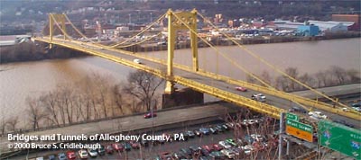
View from Blvd of the Allies at Duquesne University 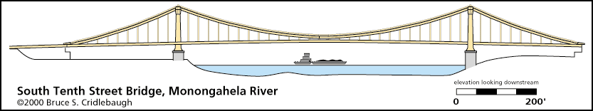
Elevation drawing looking downstream More detail photos OFFICIAL NAME: South Tenth Street Bridge OTHER DESIGNATION: Tenth Street Bridge pghe585-35 LOCATION: Pittsburgh USGS 7.5" Topo Quad - UTM Coordinates: Pittsburgh East - Zone 17; 0585 4476 CARRIES: motor vehicles, four lanes undivided BETWEEN: -- Second Av and Armstrong Tunnels on right descending bank of Monongahela River -- South Tenth St on left descending bank of Monongahela River CROSSES: (RDB to LDB) north approach: Eliza Furnace ("Jail Trail") bike/hike trail [formerly BO RR yard]; Penn Lincoln Parkway East [I-376, US22, US30] main spans: Monongahela River at mile 1.5 south approach: CSX RR (PLE) TYPE OF CONSTRUCTION / DESIGN: Steel suspension stone piers LENGTH OF MAIN SPAN: 725 ft 705.7 ft clearance TOTAL LENGTH (including longest elevated ramp): 1,275 ft HEIGHT OF DECK: 50.3 ft clearance Emsworth Dam normal pool level 710 ft YEAR ERECTED / ENGINEER: 1933 George S. Richardson, with A. D. Nutter and Sidney A. Shubin ADDITIONAL INFO: The overall color of the superstructure is yellow. At the top of the south tower, an unnamed artist has painted a series of black animal figures variously described as dinosaurs, ducks or geese. Each hand-painted figure is about six feet tall and may be plainly seen from the north shore of the Mon River. Other "unofficial" public works of art by this artist include rams painted on the roof of the Mackintosh-Hemphill building located near the bridge's south portal. Longest span on Monongahela River. Fourth longest span in Allegheny County (West End, 755 ft; I-79 Neville Island, 752 ft; McKees Rocks, 750 ft). FIELD CHECKED: INFO SOURCES: USACE Monongahela River Nav. Charts; Kidney: "Pittsburgh's Landmark Architecture;" Chris Potter: "You Had To Ask" Submit info or inquiry - share some facts or ask a question. Introduction -- Nearby Structures Page created: Last modified: 01-Sep-2004 |
View Larger Map View Larger Map 
| |
| copyright: © Bruce S. Cridlebaugh 1999-2008 All Rights Reserved | |||