| Home > All By Location regional map > New Kensington West > Tarentum Bridge | |||
|
|
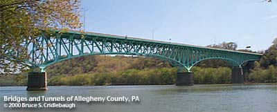
View southeast from Tarentum Point Park 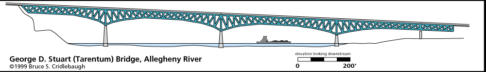
Elevation drawing looking downstream More detail photos OFFICIAL NAME: George D. Stuart Bridge OTHER DESIGNATION: Tarentum Bridge nknw605-5 LOCATION: Tarentum (Allegheny Co.) - New Kensington (Westmoreland Co.) USGS 7.5" Topo Quad - UTM Coordinates: New Kensington West - Zone 17; 0605 4494 CARRIES: motor vehicles, 4 lanes, PA366 BETWEEN: -- PA366, intersecting with Seventh Av (Tarentum, Allegheny Co.) on right descending bank of Allegheny River -- PA366 (New Kensington, Westmoreland Co.) on left descending bank of Allegheny River CROSSES: Allegheny River at Mile 21.7 TYPE OF CONSTRUCTION / DESIGN: braced spandrel arch (cantilever) Pratt deck truss LENGTH OF MAIN SPAN: 428.0 ft clearance channel span TOTAL LENGTH (including longest elevated ramp): HEIGHT OF DECK: 47.9 ft clearance near right channel pier, deck is inclined from approx. 50 ft height at south end to approx.150 deck height at north end Lock and Dam No. 3, Acmetonia, normal pool level 734.5 ft YEAR ERECTED / ENGINEER: 1952, Pennsylvania Dept of Highways ADDITIONAL INFO: Opened 18 Feb 1952. Originally a toll bridge: cars, 10 cents; trucks, 25 cents. Toll booth was located on the Westmoreland County side. Tolls were removed in 1961 as the last state-maintained toll bridge. Before the bridge was built, the nearest crossings were at Freeport (Garvers Ferry Bridge) and New Kensington (Ninth Street Bridge). Originally named the Tarentum-Valley Heights Bridge. In the 1960s, the New Kensington-Tarentum Bridge. Officially renamed on 1 June 1973, George D. Stuart Bridge to honor the former editor of the Valley News Dispatch newspaper and three-term State House member. Rep. Stuart pushed for the $4.5 million to build the structure. Ramps in Tarentum replaced the Ross St Viaduct, both in location and in function. The viaduct, closed in 1949, was built in 1903 to allow trolley and motor vehicle to cross the Pennsylvania Railroad between Third St and Sixth St. The PRR tracks mark the route of the Pennsylvania Canal which crosses Lock St north of the Tarentum Bridge. FIELD CHECKED: 20-Oct-1999 INFO SOURCES: field check; USACE Allegheny River Nav. Charts; Valley News Dispatch, 14 Feb 1999 Submit info or inquiry - share some facts or ask a question. Introduction -- Nearby Structures Page created: Last modified: 02-May-2000; 29-Feb-2016 |

| |
| copyright: © Bruce S. Cridlebaugh 1999-2016 All Rights Reserved | |||