| Home > Structures Listed by Location - USGS 7.5" topo quad: NEW KENSINGTON EAST | |||
|
|
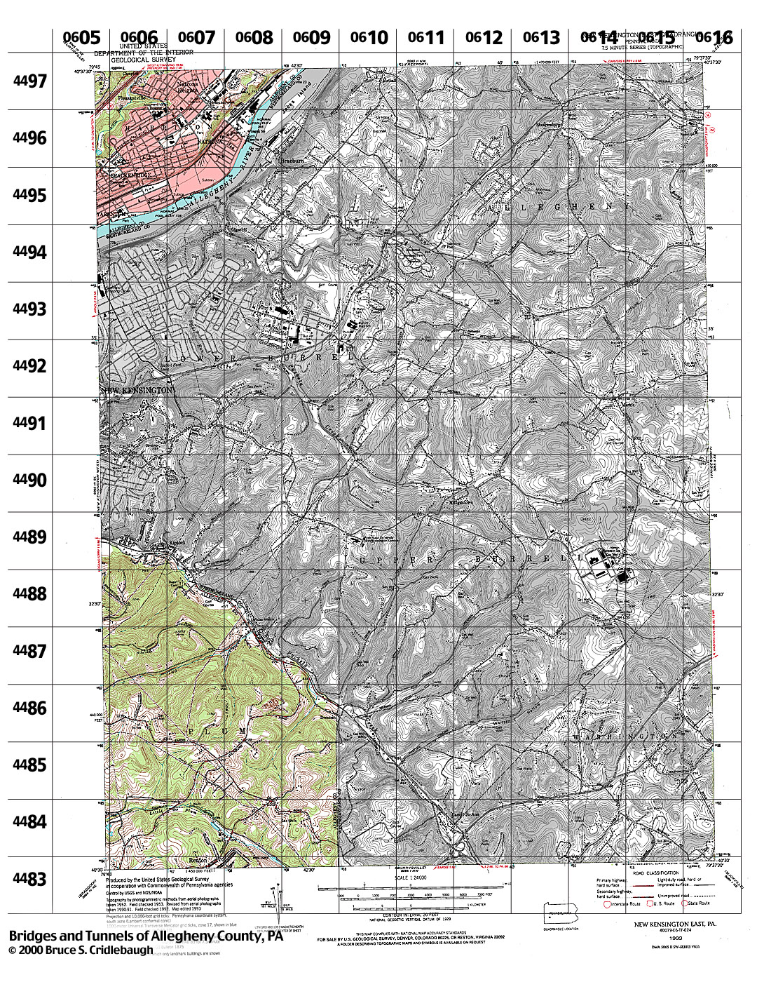
Structures Listed by Location NEW KENSINGTON EAST, PA - USGS 7.5" Topo Quad - UTM grid location in BOLD view map - initial listings completed 25-Jan-2000 * indicates unconfirmed crossing
79° 45' 00" W --- 79° 37' 30" W;
0605 4497 - none listed
0605 4496 - none listed
0605 4495 - none listed
0605 4494 - none listed
0605 4489 - none listed
0605 4488 - none listed
0605 4487 - none listed
0605 4486 - none listed
0605 4485 - none listed
0605 4484 - none listed
0605 4483 - none listed
0606 4497
- Pleasantville Rd over Little Bull Creek (Harrison)
0606 4496 - none listed
0606 4495
- Morgan St at Conrail (Brackenridge)
0606 4489 - Crystal Dr over Pucketa Creek (Plum, Allegheny Co. - Lower Burrell, Westmoreland Co.)
0606 4488 - none listed
0606 4487 - none listed
0606 4486 - none listed
0606 4485 - Ross Hollow Rd over tributary of Little Plum Creek (Plum)
0606 4484
- Stotler Rd over Little Plum Creek (Plum)
0606 4483 - none listed
0607 4497 - none listed
0607 4496 - Philadelphia St at Conrail (Harrison)
0607 4495 - none listed
0607 4489 - none listed
0607 4488
- Greensburg Rd [PA366] over Pucketa Creek, at Albee Dr (Plum, Allegheny Co. - Lower Burrell, Westmoreland Co.)
0607 4487 - none listed
0607 4486 - none listed
0607 4485 - none listed
0607 4484
- Leechburg Rd over Little Plum Creek (Plum)
0607 4483 - none listed
0608 4497 - none listed
0608 4496
- Diamond Alley / Alder St ? at Conrail (Harrison)
0608 4495 - none listed
0608 4488 - none listed
0608 4487
- Webster Rd / Alta Dr ? over Pucketa Creek, at Albee Dr (Plum, Allegheny Co. - Lower Burrell, Westmoreland Co.)
0608 4486 - none listed
0608 4485 - none listed
0608 4484
- Renton Rd at Unity RR [abandoned] (Plum)
0608 4483 - none listed
0609 4497 - none listed
0609 4487
- Myers Rd over Pucketa Creek (Plum, Allegheny Co. - Upper Burrell, Westmoreland Co.)
0609 4486 - Drennen Rd over tributary of Pucketa Creek (Plum)
0609 4485 - none listed
0609 4484 - none listed
0609 4483 - none listed
Submit info or inquiry - share some facts or ask a question.
Page created:
|
| |
| copyright: © Bruce S. Cridlebaugh 1999-2008 All Rights Reserved | |||