| Home > All By Location regional map > Murrysville > PA Turnpike over Turtle Creek | |||
|
|
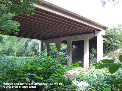
View upstream More detail photos OFFICIAL NAME: WB-466; MP 58.95 PENNDOT BMS NUMBER: 027076990058950 OTHER DESIGNATION: PA Turnpike over Turtle Creek LOCATION: Monroeville (Allegheny County) - Penn Twp. (Westmoreland County) LATITUDE, LONGITUDE: 40.408811, -79.722215 USGS 7.5" Topo Quad - UTM Coordinates: Murrysville - Zone 17; 0608 4473 CARRIES: -- PA Turnpike [I-76], 4 lanes BETWEEN: -- MP 58.95 CROSSES: -- Turtle Creek TYPE OF CONSTRUCTION / DESIGN: deck steel continuous stringer LENGTH OF MAIN SPAN: 3 spans: 65 ft, 86 ft over Turtle Creek, 65 ft (all spans est) TOTAL LENGTH (including longest elevated ramp): 216 ft HEIGHT OF DECK: 82 ft width YEAR ERECTED / ENGINEER: 1951, Buchart Horn engineers for Western Extension Pennsylvania Turnpike Commission Rehab and widened 1992 ADDITIONAL INFO: Turtle Creek forms the border between Allegheny and Westmoreland counties. Before construction of the Turnpike, this was the site of a railraod bridge carrying the Lyons Run branch of the Pennsylvania Railroad. Cut stone from the earlier bridge are still present, scattered in the nearby stream. FIELD CHECKED: - INFO SOURCES: field check Submit info or inquiry - share some facts or ask a question. Introduction -- Nearby Structures Page created: 10-Aug-2009 Last modified: 25-Oct-2009 No warranty whatsoever -- express or implied -- as to the accuracy, reliability or completeness of furnished data. |
View Larger Map 
| |
| copyright: © Bruce S. Cridlebaugh 1999-2009 All Rights Reserved | |||