| Home > All By Location regional map > Murrysville > McGregor Rd over Thompson Run Run | |||
|
|
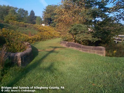
View west More detail photos OFFICIAL NAME: OTHER DESIGNATION: McGregor Rd over Thompson Run "Old Stone Bridge" murr606-15 LOCATION: Monroeville USGS 7.5" Topo Quad - UTM Coordinates: Murrysville - Zone 17; 0606 4477 CARRIED: -- McGregor Rd BETWEEN: -- west of intersection of Old William Penn Highway and Beatty Rd CROSSES: -- Thompson Run, tributary of Abers Creek TYPE OF CONSTRUCTION / DESIGN: stone arch locally-quarried sandstone outer spandrel wall: rock-faced coursed ashlar upper walls and parapets: dressed coursed ashlar arch ring: dressed voussoirs in segmental arch LENGTH OF MAIN SPAN: 16 ft 20 degree skew TOTAL LENGTH (including longest elevated ramp): 46 ft 19 ft wide, between parapets HEIGHT OF DECK: YEAR ERECTED / ENGINEER: c1870-1900, Allegheny County Charles Davis, county engineer ADDITIONAL INFO: [I discovered this bridge near my home when I was a kid. It was an important influence in developing the interest which led to this project.] The Braddock and Forbes Roads had been built as military roads to Pittsburgh, 1755 and 1758 respectively. The routes suited their purposes, but over time, the State Road modified the main route from the east. Each passed a couple miles south or north of this location -- later routes split the difference. An 1806 act authorized a new turnpike to be constructed, with commisioners in the various counties along its route. Dividing the routes into section made fundraising by stock subscription easier. An 1811 act authorized the commonwealth to provide $300,000 to the company which could raise $150,000 in stock. A competition developed between the southern route (which included the Greensburg Pike) and what would become the Northern Turnpike. The rivalry delayed the construction of both. In the early 1920s, the Pennsylvania Department of Highways built William Penn Highway as an improved two-lane highway which substantially followed the Northern Turnpike. After entering Allegheny County from the east, the new highway crossed Abers Creek and diverged from the old pike. Northern Pike begins a difficult climb to follow a ridge line; William Penn Highway takes a more northern route following an older local road on the water level route of the Thompsons Run tributary of Abers Creek. In this valley where Jno and Wm Thompson were landowners, the old road traced a route to a point near the home of Alex McGregor where the valley splits into two: Beatty Road turns north; McGregor Road continued more westwardly to ascend a ridgeline. The old McGregor Rd has been substantially erased -- having formerly run along the current Shackleford Drive and onto the plateau which holds the suburban strip of Monroeville. During years surrounding 1900, Allegheny County, under the direction of County Engineer Charles Davis, was busy throughout the county building stone arch bridges of a simple and similar design. This bridge exhibits the more common design features of the County's stone bridges -- parapets with rounded top and horizontal curves at the portals. This crossing of McGregor Rd over the northern branch of Thompson Run features one of the structures. Some sources claim the McGregor Rd Bridge, aka "Old Stone Bridge," to have been built c1870. But due to its similarity to others by Davis, it is most likely no less than twenty years newer. The design and construction details match many others still standing elsewhere in the county. When the William Penn Highway was constructed c1924, its westward course proceeded between McGregor and Beatty roads to follow a more gradual rise on its way to Pittsburgh. The improved highway and later construction caused McGregor Rd to fall into disuse. The Old Stone Bridge was bypassed by the 1924 William Penn Highway, which in turn was bypassed but not altogether replaced by a realignment to the north of William Penn Highway in 1942. The Old Stone Bridge was threatened by the construction of a shopping plaza in 1982. The Hill's department store donated the bridge and small piece of surrounding land to the Municipality of Monroeville to be maintained by the Monroeville Historical Society. It was declared a local historic landmark at that time and received a Pittsburgh History and Landmarks Foundation in 1985. The bridge is featured on engraved cards and other items by the Monroeville Historical Society. from the Monroeville Historical Society: Monroeville dates back to 1810 when the Old Northern Pike was opened for stage coach travel between Pittsburgh and Philadelphia. The tiny hamlet extended from the house of Abraham Taylor, later the residence of Sara Warner Dixon, up to the Old Stone Church. There were two blacksmith shops, two stores and a post office. Monroeville was named in 1851, possibly for President James Monroe, but probably for its first Postmaster, John Joel Monroe, who lived on what later became the Duff Farm. The Municipality of Monroeville was incorporated on January 25, 1951 (from Patton Township). On January 5, 1976, The Municipality of Monroeville became a Home Rule Charter Municipality. FIELD CHECKED: 30-Sep-2002 INFO SOURCES: field check; Swetnam & Smith "Guidebook to Historic Western PA"; Allegheny County Centennial Committee history, 1888; Collins, "Stringtown on the Pike"; Boucher, "Old and New Westmoreland", 1918; Kidney, "Pittsburgh Bridges: Architecture and Engineering" Submit info or inquiry - share some facts or ask a question. Introduction -- Nearby Structures Page created: Last modified: 13-Jan-2003 |
View Larger Map 
| |
| copyright: © Bruce S. Cridlebaugh 1999-2008 All Rights Reserved | |||