| Home > All By Location regional map > Glenshaw > Old PA 8 over Gourhead Run | |||
|
|
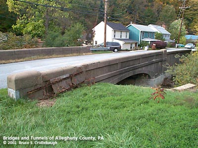
View north (downstream right) with extended retaining wall to northeast More detail photos OFFICIAL NAME: Allegheny County Bridge Number 2 Gourdhead Run OTHER DESIGNATION: Old PA 8 Rd over Gourhead Run [Gourdhead Run] Old Butler Plank Rd over Gourhead Run glen588-18 LOCATION: Hampton USGS 7.5" Topo Quad - UTM Coordinates: Glenshaw - Zone 17; 0588-4490 CARRIES: Old PA 8 Rd ["oxbow" bypassed section of Old Butler Plank Rd] BETWEEN: -- south of Herron Rd -- William Flinn Highway [PA 8] CROSSES: -- Gourhead Run [Gourdhead Run] TYPE OF CONSTRUCTION / DESIGN: Closed spandrel concrete arch; Parapet walls: concrete formed modules LENGTH OF MAIN SPAN: 42 ft TOTAL LENGTH (including longest elevated ramp): HEIGHT OF DECK: YEAR ERECTED / ENGINEER: 1914, Allegheny County James Graham Chalfant, County Engineer ADDITIONAL INFO: During years surrounding 1900, Allegheny County, under the direction of County Engineer Charles Davis, was busy throughout the region building stone arch bridges of a simple and similar design. Typically, they featured parapets with rounded top and slightly enlarged parapet endcaps. Beginning about 1910 -- after Chalfant assumed the position of County Engineer -- new county bridges of this size were being constructed solely in concrete using a design which mimicked the earlier stone arches. On a few of the concrete structures, a builder's plate identifies the bridge as having been constructed by Allegheny County and includes the stream name and date. Several bridges of this design are found throughout Allegheny County, but usually without the builder's plate to confirm the date or the authority in charge of construction. The similar of design and construction seems to imply that they were all built by Allegheny County, and other sources state construction dates to about 1936. This arched design was phased out and replaced by simpler beam bridges. The arch portion of the bridge seems reasonably intact, but the parapet walls are severely crumbling. Examination of the other bridges of this design show a similar pattern. The parapets appear to have been constructed by stacking a series of formed concrete modules. The modules were shaped to mimic the rounded caps found on County bridges designed by Davis. Each block seems to have weathered differently and the seams between them allowed further decay. The Old Butler Plank Rd bridge over Gourhead Run is possibly the best preserved example. The closed spandrel walls and outer faces of the parapets have recessed panels which further echo the designs from the County's earlier stone arch bridges. The parapets are most similar to those created in stone for Merriman Rd over Big Sewickley Creek. Allegheny County assigns its bridges with an ID number counting from a stream's outflow, sequentially upstream. The pattern is broken in this instance: this is the third County bridge upstream from the point where Gourhead Run flows into Pine Creek; it was completed further upstream in 1914 and given the designation of Bridge Number 2. In 1919, Duncan Av replaced Naylor Av as the connection between Butler Plank Rd (soon after bypassed by William Flinn Highway) with the Old Butler Turnpike (Mt. Royal Blvd). The newer bridge built downstream to carry Duncan Av over Gourhead Run was given the Number 3 designation. Older maps (including the 1876 Hopkins map) show the name of this stream as Gourhead Run; more recent maps and records often list the name as "Gourdhead" or"Gourdehead." The Hopkins map shows the name of early settlers in the area having Scotch-Irish surnames: McCaslin, McCully, McClay, McNeal, and others (About 2/3 mile above this bridge, McCaslin's Run flows into Gourhead Run.). Curiosity about the name discrepency led to two possibilities. Named for the Gaelic word for goat, the River Gour flows into Loch Linnhe in the Highlands of Scotland. And the geological term "gour" refers to a formation found in caves and flowing streams. Where mineral-laden streams form small still pools, deposits may build up a raised rim of stone -- the rimstone is a "gour." It is possible, given the course of Gourhead Run through the limestone and other sedimentary rock layers, the early settlers recognized the formations. "Gour" is such an obscure word in either meaning; perhaps later mapmakers transcribed the name into something more recognizable. Farther upstream on Gourhead Run, northwest of the intersection of Harts Run Rd and Rosanna Dr, the hill rising up is named "Gourhead Knob" on the 1876 map. Ground was broken in June 1851 by the Allegheny City and Butler Plank Road Company to build one of the earliest improved roads north of Pittsburgh. With the arrival of the motor age, these older "improved" roads were rebuilt. This bridge was constructed in 1914 as part of the Butler Plank Rd. The Pittsburgh-Butler Highway was straightened and widened again in 1931-32 at which time, this bridge was bypassed in the same way a meandering river isolates an oxbow lake. This short section of the Old Butler Plank Road was renamed as Old PA 8 Road. Upon the death of a prominent contractor and politician, the new road was named William Flinn Highway. FIELD CHECKED: 21-Oct-2002 INFO SOURCES: field check; cited map; UK Ordnance Survey Submit info or inquiry - share some facts or ask a question. Introduction -- Nearby Structures Page created: Last modified: 16-Apr-2003 |
View Larger Map 
| |
| copyright: © Bruce S. Cridlebaugh 1999-2008 All Rights Reserved | |||