| Home > All By Location regional map > Glenshaw > Pennview St over Pine Creek | ||||
|
|
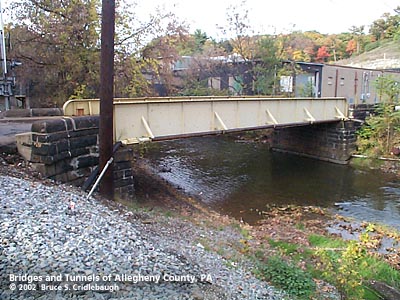
View north from CSX RR (downstream right) More detail photos OFFICIAL NAME: Allegheny County Bridge Number 11 Pine Creek OTHER DESIGNATION: Pennview St over Pine Creek glen588-34 LOCATION: Shaler USGS 7.5" Topo Quad - UTM Coordinates: Glenshaw - Zone 17; 0588-4485 CARRIES: Pennview St BETWEEN: -- William Flinn Hwy [PA8] -- CSX RR; Emma Dr CROSSES: -- Pine Creek TYPE OF CONSTRUCTION / DESIGN: riveted steel plate girder abutments: locally-quarried sandstone, rock-faced coursed ashlar LENGTH OF MAIN SPAN: 59.6 ft TOTAL LENGTH (including longest elevated ramp): 84 ft est HEIGHT OF DECK: 6 ft est clearance 12 ft wide road surface; 17.3 ft between girders YEAR ERECTED / ENGINEER: 1902, Allegheny County Charles Davis, engineer ADDITIONAL INFO: A metal builder's plaque is riveted toward the left end of the upstream girder:
An additional metal builder's plaque:
During years surrounding 1900, Allegheny County, under the direction of County Engineer Charles Davis, was busy throughout the county building stone arch bridges of a simple and similar design. In some places, however, the crossings were built as riveted plate girder spans. The abutments of these girder bridges exhibit similar stonework to the County's stone bridges -- helping to identify their place in time and origin. A glance at the construction dates indicates that many of the earlier bridge were of the girder type. One possible explanation for the choice of an arch span versus a girder span may be found in the shape of the land onsite. Where the stream has high banks and can therefore hold rising waters of a flash flood, the bridges are usually stone arches. In places with relatively wide, flat channels, the spans are most often girders. In each instance, the goal was to maintain the level of the road surface as the road approaches and then enters the bridge -- while allowing maximum potential stream flow; sites which made this impractical have since been regraded or replaced. Allegheny County assigns its bridges with an ID number counting from a stream's outflow, sequentially upstream. A cast number "11" is affixed to the center of the upstream girder indicating this as the eleventh bridge upstream from the point where Pine Creek flows into the Allegheny River (Pine Creek Number 11). The bridge carries a natural gas pipe line on the outside of the downstream girder. The CSX railroad tracks adjacent to the western end of the bridge are part of a line originally built as the Allegheny and Harmony Railroad in 1872. The narrow gauge railroad was incorporated under the name Pittsburg, New Castle & Lake Erie Railroad in 1877. After a sheriff's sale, it became part of the Pittsburgh & Western Railroad Company which consolidated several lines north and west of Pittsburgh, converting the railroad to standard gauge. It was taken over by the Baltimore and Ohio Railroad in 1893. It served a the mainline between Pittsburgh and Chicago until the B&O was able to acquire the Pittsburgh & Lake Erie's Ohio River route. More info - Pittsburgh & Western Railroad Company FIELD CHECKED: 21-Oct-2002 INFO SOURCES: field check Submit info or inquiry - share some facts or ask a question. Introduction -- Nearby Structures Page created: Last modified: 11-Apr-2003 |
View Larger Map View Larger Map 
| ||
| copyright: © Bruce S. Cridlebaugh 1999-2008 All Rights Reserved | ||||