| Home > All By Location regional map > Emsworth > Ohio River Boulevard over Spruce Run | |||
|
|
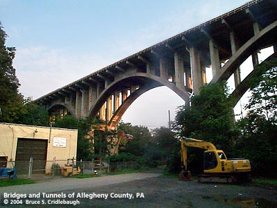
View southeast (away from Ohio River) on Spruce Run Rd More detail photos OFFICIAL NAME: Spruce Run Bridge OTHER DESIGNATION: Ohio River Boulevard over Spruce Run LOCATION: Ben Avon USGS 7.5" Topo Quad - UTM Coordinates: Emsworth - Zone 17; 0578 4483 CARRIES: Ohio River Boulevard [PA65] BETWEEN: -- Dickson Av -- Park St CROSSES: -- Spruce Run -- Spruce Run Rd TYPE OF CONSTRUCTION / DESIGN: Deck open spandrel concrete arch LENGTH OF MAIN SPAN: 150 ft (3 arch spans, plus approaches) TOTAL LENGTH (including longest elevated ramp): 752 ft HEIGHT OF DECK: YEAR ERECTED / ENGINEER: 1930, Allegheny County ADDITIONAL INFO: from the PennDOT Historic Bridges Survey: "The bridge carries a 4 lane highway and 2 sidewalks over a stream and local road on the north bank of the Ohio River in a setting dominated by a mix of residential and modern commercial development. It was built as part of the Ohio River Boulevard, the highway designed to speed traffic to the McKees Rocks bridge. The highway has lost integrity due to alterations to its original geometry and roadside features as well as extensive modern development along it. Neither the highway nor the setting have historic district potential. FIELD CHECKED: 14-Aug-2004 INFO SOURCES: field check, PennDOT Historic Bridges Survey Submit info or inquiry - share some facts or ask a question. Introduction -- Nearby Structures Page created: Last modified: 04-Oct-2004 |
View Larger Map View Larger Map View Larger Map 
| |
| copyright: © Bruce S. Cridlebaugh 1999-2008 All Rights Reserved | |||