Search pghbridges.com
Search WWW


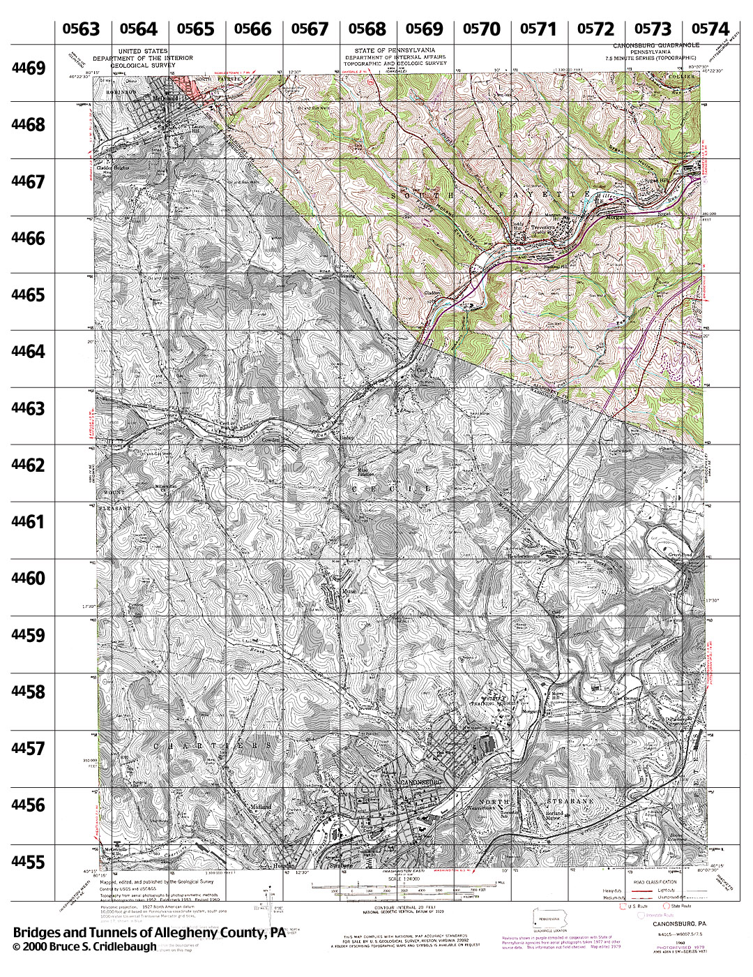
Structures Listed by Location
CANONSBURG, PA - USGS 7.5" Topo Quad - UTM grid location in BOLD
view map - initial listings completed 03-Feb-2000
* indicates unconfirmed crossing

80° 15' 00" W --- 80° 07' 30" W;
40° 22' 30" N --- 40° 15' 00" N


Also try the Tours.


0565 4469
grid location also on Oakdale topo quad

- Laurel Hill Rd over Robinson Run (McDonald)


0565 4468

- Laurel Hill Rd at Conrail (McDonald)


0566 4469
grid location also on Oakdale topo quad

- none listed


0566 4468

- none listed


0566 4467

- none listed


0567 4469
grid location also on Oakdale topo quad

- none listed


0567 4468

- none listed


0567 4467

- none listed


0567 4466

- none listed


0568 4469
grid location also on Oakdale topo quad

- none listed


0568 4468

- none listed


0568 4467

- none listed


0568 4466

- none listed


0568 4465

- none listed


0569 4469
grid location also on Oakdale topo quad

- none listed


0569 4468

- none listed


0569 4467

- Campbells Rd over Fishing Run (South Fayette)
- Road off Campbells Rd over Fishing Run (South Fayette)


0569 4466

- none listed


0569 4465

- NW RR [former Wabash] over Millers Run, north of Reed St (South Fayette)
- NW RR [former Wabash] over Millers Run, south of Reed St (South Fayette)
- PA50 over Millers Run and Conrail (South Fayette)
- NW RR [former Wabash] over Cecil-Sturgeon Rd (South Fayette)


0569 4464

- none listed


0570 4469
grid location also on Oakdale topo quad

- none listed


0570 4468

- none listed


0570 4467

- none listed


0570 4466

- Campbells Rd over Fishing Run (South Fayette)
- Millers Run Rd [PA978] over Fishing Run (South Fayette)
- Conrail spur over Fishing Run (South Fayette)
- Conrail over Fishing Run (South Fayette)
- NW RR [former Wabash] over Millers Run and Conrail (South Fayette)
- Oakdale Rd [PA978] over Dolphin Run (South Fayette)
- Millers Run Rd [PA978] over Dolphin Run (South Fayette)
- Conrail over Dolphin Run (South Fayette)


0570 4465

- PA50 over Millers Run (South Fayette)
- NW RR [former Wabash] over Millers Run, at Parks Rd (South Fayette)
- Conrail at Parks Rd (South Fayette)
- Parks Rd over Millers Run (South Fayette)
- Parks Rd over Mosquito Hollow tributary of Millers Run (South Fayette)


0570 4464

- none listed


0571 4469
grid location also on Oakdale topo quad

- Sygan Hill Rd over Sygan Hollow tributary of Millers Run (South Fayette)


0571 4468

- none listed


0571 4467

- none listed


0571 4466

- NW RR [former Wabash] at western end of Fayette St (South Fayette)
- NW RR {former Wabash] at Millers Run Rd, at Morgan Hill Rd (South Fayette)
- Millers Run Rd over Millers Run, at Morgan Hill Rd (South Fayette)
view photo - Alpine Road (pedestrian bridge) over NW RR [former Wabash] (South Fayette)


0571 4465

- none listed


0571 4464

- Karmann Rd over tributary of Coal Run (South Fayette)


0571 4463

- none listed


0572 4469
grid location also on Oakdale topo quad

- none listed


0572 4468

- none listed


0572 4467

- Conrail over tributary of Millers Run, west of Cherry St (South Fayette)
- Morgan Hollow Rd over Millers Run (South Fayette)
- Conrail at Morgan Hollow Rd (South Fayette)


0572 4466

- none listed


0572 4465

- none listed


0572 4464

- Coal Pit Rd over Coal Run, north of Bowman Rd (South Fayette)
- Coal Pit Rd over tributary of Coal Run, north of Bowman Rd (South Fayette)


0572 4463

- County Line Rd over I-79 (South Fayette)
- Morganza Rd [Washington Pike, old William Flinn Hwy] over tributary of Chartiers Creek (South Fayette)


0573 4469
grid location also on Oakdale topo quad

- none listed


0573 4468

- Hill Rd over tributary of Millers Run (South Fayette)


0573 4467

- Millers Run Rd over Millers Run, at Sygan Hill Rd (South Fayette)
- NW RR [former Wabash] over Millers Run Rd and Millers Run (South Fayette)
- Presto-Sygan Rd over Sygan Hollow tributary of Millers Run (South Fayette)
- NW RR [former Wabash] over Presto-Sygan Rd (South Fayette)
- Millers Run Rd over Sygan Hollow tributary of Millers Run (South Fayette)
- Conrail over Sygan Hollow tributary of Millers Run (South Fayette)
- Industrial road off Presto-Sygan Rd over Millers Run (South Fayette)
- NW RR [former Wabash] over Millers Run, at factories (South Fayette)
- Millers Run Rd over Millers Run, at factories (South Fayette)
- Conrail over Millers Run, at factories (South Fayette)


0573 4466

- none listed


0573 4465

- Alpine Dr over I-79 (South Fayette)
- Road between Alpine Dr and Hickory Grade Rd over Coal Run (South Fayette)


0573 4464

- Morganza Rd [Washington Pike, old William Flinn Hwy] over tributary of Chartiers Creek, south of Camp Meeting House Rd (South Fayette)


0573 4463

- none listed


0574 4469
grid location also on Bridgeville and Oakdale topo quads

- none listed


0574 4468
grid location also on Bridgeville topo quad

- Presto-Sygan Rd over tributary of Millers Run, at Bethany Cemetery (South Fayette)


0574 4467
grid location also on Bridgeville topo quad

- none listed


0574 4466
grid location also on Bridgeville topo quad

- none listed


0574 4465
grid location also on Bridgeville topo quad

- Oak Dr over creek, off Morganza Rd (South Fayette)


0574 4464
grid location also on Bridgeville topo quad

- none listed


0574 4463
grid location also on Bridgeville topo quad

- none listed


0574 4462
grid location also on Bridgeville topo quad

- none listed


Submit info or inquiry - share some facts or ask a question.

Page created: 03-Feb-2000
Last modified: 24-Mar-2015


sidebar