| Home > All By Location regional map > Bridgeville > McLaughlin Run Rd #5 over McLaughlin Run Run | |||
|
|
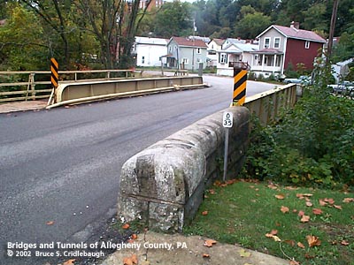
View south (downstream right), Maple St intersects from right beyond bridge More detail photos OFFICIAL NAME: Allegheny County Bridge Number 5 McLaughlin Run OTHER DESIGNATION: McLaughlin Run Rd #5 over McLaughlin Run brid575-14 LOCATION: Bridgeville USGS 7.5" Topo Quad - UTM Coordinates: Bridgeville - Zone 17; 0575-4467 CARRIES: McLaughlin Run Rd [S.R.3004, Orange Belt] BETWEEN: -- at Maple St CROSSES: -- McLaughlin Run TYPE OF CONSTRUCTION / DESIGN: riveted steel plate girder abutments: locally-quarried sandstone, rock-faced coursed ashlar LENGTH OF MAIN SPAN: 40 ft TOTAL LENGTH (including longest elevated ramp): ft HEIGHT OF DECK: YEAR ERECTED / ENGINEER: 1905, Allegheny County Charles Davis, engineer Replaced 2011 ADDITIONAL INFO: A metal builder's plaque is riveted to the center of the downstream girder:
During years surrounding 1900, Allegheny County, under the direction of County Engineer Charles Davis, was busy throughout the county building stone arch bridges of a simple and similar design. In some places, however, the crossings were built as riveted plate girder spans. The abutments of these girder bridges exhibit similar stonework to the County's stone bridges -- helping to identify their place in time and origin. A glance at the construction dates indicates that many of the earlier bridge were of the girder type. One possible explanation for the choice of an arch span versus a girder span may be found in the shape of the land onsite. Where the stream has high banks and can therefore hold rising waters of a flash flood, the bridges are usually stone arches. In places with relatively wide, flat channels, the spans are most often girders. In each instance, the goal was to maintain the level of the road surface as the road approaches and then enters the bridge -- while allowing maximum potential stream flow; sites which made this impractical have since been regraded or replaced. Allegheny County assigns its bridges with an ID number counting from a stream's outflow, sequentially upstream. This was the fifth bridge upstream from the point where McLaughlin Run flows into Chartiers Creek. On the inside of the downstream girder, there is a hand-drawn diagram with notes regarding the deck structure. In its 15 inches of thickness, there is a 7 inch thick metal grid base, topped with 2 inch thick brick, covered with a 6 inch thick layer of asphalt. FIELD CHECKED: 13-Oct-2002 INFO SOURCES: field check Submit info or inquiry - share some facts or ask a question. Introduction -- Nearby Structures Page created: Last modified: 07-Apr-2003 |
View Larger Map View Larger Map 
| |
| copyright: © Bruce S. Cridlebaugh 1999-2008 All Rights Reserved | |||