|
Two views southwest
More detail photos
OFFICIAL NAME:
Allegheny County Bridge No. 4 Turtle Creek
OTHER DESIGNATION:
Mosside Bridge
brad604-11 (main), brad603-31
LOCATION:
Monroeville, North Versailles
USGS 7.5" Topo Quad - UTM Coordinates:
Braddock - Zone 17; 0604 4472 (1927 NAD)
south approach and "back channel" span in 0604 4471
CARRIES:
PA48 [Mosside Blvd, Orange Belt] - two lanes
BETWEEN:
-- PA State Route 130 [Broadway Blvd.], Monroeville
-- Wall Road, North Versailles
CROSSES:
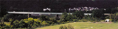
-- Norfolk Southern Railroad [former PRR Main Line] - three tracks
-- Norfolk Southern Railroad tracks for Intermodal Terminal at Pitcairn, PA
-- Turtle Creek
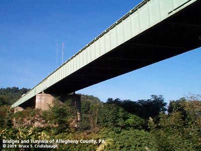
TYPE OF CONSTRUCTION / DESIGN:
Main: through steel plate girder - riveted
sections are cantilevered and pinned
Span at Wall Av: deck steel plate girder
LENGTH OF MAIN SPAN:
221 ft
TOTAL LENGTH (including longest elevated ramp):
812 ft (four spans),
plus 89 ft. curved skew span at Wall Av
HEIGHT OF DECK:
70 ft est
YEAR ERECTED / ENGINEER:
1930, County of Allegheny
Replaced 2006-2007
ADDITIONAL INFO:
First bridge to be featured in pghbridges.com -- February 22, 1999.
Replaced smaller bridge. Old piers are adjacent to west.
Mosside Blvd (aka Moss Side Blvd) was part of the same 1928 bond issue as Ohio River Blvd, Saw Mill Run Blvd, and Allegheny River Blvd. But Mosside (perhaps because it was not built in the urban area -- or touching the City of Pittsburgh) did not receive the sculpted concrete entrance pylons as did the others. All of these roads were projects of the County of Allegheny.
from the PennDOT Historic Bridges Survey:
Main structure:
The 5 span, 812'-long, thru girder bridge is composed of four continuous-cantilever thru girder spans (182'-221'-180'-180') built in 1930 and a prestressed concrete spread box beam approach span (46') from 1979. The 221'-long span of the continuous-cantilever thru girder bridge has a drop in section with shiplap connections. The bridge has built up floorbeams, rolled stringers and a concrete deck. It has a cantilevered sidewalk, pipe railings with bar fill, and a concrete substructure. The bridge is historically and technologically significant as an early statewide example of a continuous-cantilever girder bridge with a drop in section with shiplap connections. The design was an important variation in the development of the steel stringer and girder bridge types. It offers economy of material and permanence because of deck joint reduction. It allows for a longer clear span with shallower beams than would have been possible with a simply supported beam. The drop in design was used nationally beginning in the late 1920s and achieved its greatest popularity after WW II. In addition to its individual technological significance, the bridge is historically significant in association with the PHMC-determined eligible PRR Main Line.
The bridge carries a 2 lane road with a sidewalk over Turtle Creek and 3 active Conrail tracks. The rail line is the former Pennsylvania RR Main Line that has been determined eligible by PHMC (9/14/93). The line is significant for its historic role as an important east-west through route established in the 1850s. The boundaries and period of significance of the line have not been specified by PHMC. The bridge is over a rail yard near the PRR's former Pitcairn Station, but most of the sidings have been removed in this area. An intermodal yard is still active south of the bridge.
Single span at Wall Av:
The 1930, skewed, single span, built up deck girder bridge is supported on concrete abutments. The fascia beams support built up girder floorbeams that in turn carry steel stringers and the reinforced concrete deck. The bridbe has non-standard, Art Moderne-influenced steel railings. The bridge is a common design type used by the railroad industry since the mid-19th century and on vehicular roadways since late in the same century.
The bridge carries Mosside Boulevard, a 2 lane state highway with 2 sidewalks, over a local service road in an area of undistinguished post-World War II strip commercial development outside of Wall borough. The bridge carries the roadway over an abandoned right of way of a Pennsylvania Railroad spur route that has been converted to an access road to an industrial yard. The bridge is not historically or technologically significant.
Metal builder's plaques are mounted on the bridge railing:
ALLEGHENY COUNTY
BRIDGE NO. 4 TURTLE CREEK
ERECTED 1930
Commissioners
Jos. G. Armstrong, Chairman E.V. Babcock Chas. G. McGovern
Department of Public Works
Director: Norman F. Brown Chief Engineer: V.R. Covell
Superstructure Contractor: Independent Bridge Co.
|
Scheduled for demolition and replacement in 2005. The PennDOT plan calls for a pair of two-lane structures, doubling the existing capacity. Upon completion of the first structure, traffic will be moved to the new bridge. The existing bridge will be removed to allow construction of the second parallel structure.
view page - More information about Mosside Bridge, the Great Valley, the PRR and PA48.
FIELD CHECKED:
11-Feb-1999; 22-Sep-2001
INFO SOURCES:
field check, builder's plate
Submit info or inquiry - share some facts or ask a question.
Introduction --
Nearby Structures
Page created:
Last modified:
01-Jul-2004, 11-Aug-2007
|
View Larger Map

|