| Home > All By Location regional map > Braddock > Broadway over Dirty Camp Run | |||
|
|
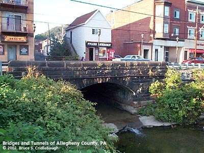
View north OFFICIAL NAME: OTHER DESIGNATION: Broadway over Dirty Camp Run brad603-24 LOCATION: Pitcairn USGS 7.5" Topo Quad - UTM Coordinates: Braddock - Zone 17; 0603 4472 CARRIES: Broadway [PA130, Broadway Blvd] BETWEEN: -- Wall Av -- Center Av CROSSES: -- Dirty Camp Run TYPE OF CONSTRUCTION / DESIGN: stone arch locally-quarried sandstone outer spandrel wall: rock-faced coursed ashlar upper walls and parapets: dressed coursed ashlar arch ring: dressed voussoirs in segmental arch LENGTH OF MAIN SPAN: TOTAL LENGTH (including longest elevated ramp): HEIGHT OF DECK: YEAR ERECTED / ENGINEER: c1900 (widened 1929?), Allegheny County Charles Davis, engineer ADDITIONAL INFO: In 1763, several Indian tribes banded together under the Ottawa chief, Pontiac, in an attempt to drive European settlement from the Ohio Valley. They laid seige to Fort Pitt, the British fort built after forcing the French to withdraw from the Point in Pittsburgh. A relief expedition led by Colonel Henry Bouquet traveled the Forbes Road from Philadelphia, but was ambushed by Pontiac's forces. The two-day Battle of Bushy Run, near Harrison City, PA, ended in a British victory. As the British troops continued westward toward Pittsburgh, they came upon the recently deserted location of the Indian encampment at the outflow of a small stream into the Turtle Creek. The deplorable conditions led Bouquet to describe the place as the "Dirty Camp." The stream has since been known as Dirty Camp Run. In the 1840s, surveys were made to locate a railroad between Harrisburg and Pittsburgh. The Pennsylvania Railroad mainline was completed through the Turtle Creek valley in 1851-52. In 1880, the PRR needed an expansion of its freight facilities in the Pittsburgh area. They purchased nearly the entire floor of the Turtle Creek Valley from Wilmerding to Trafford with the small towns of Wall (south of the tracks) and McGinnisville (to the north) near the center of the valley's sweeping arc. Many railroad workers settled on the northern side of the railyard in a town which spread up the hillsides on either side of Dirty Camp Run. In 1894 they separated from Patton Township and incorporated as the Borough of Pitcairn -- named for Robert Pitcairn, the Superintendent of the Pittsburgh Division of the Pennsylvania Railroad. Paved streets did not come to Pitcairn until 1901. A 1901 aerial drawing of the town shows the stone arch bridge carrying Broadway over Dirty Camp Run. During years surrounding 1900, Allegheny County, under the direction of County Engineer Charles Davis, was busy throughout the county building stone arch bridges of a simple and similar design. This bridge exhibits the more common design features of the County's stone bridges -- parapets with rounded top and horizontal curves at the portals. FIELD CHECKED: 7-Oct-2002 INFO SOURCES: field check Submit info or inquiry - share some facts or ask a question. Introduction -- Nearby Structures Page created: Last modified: 09-Jan-2003 |
View Larger Map View Larger Map 
| |
| copyright: © Bruce S. Cridlebaugh 1999-2008 All Rights Reserved | |||