| Home > All By Location regional map > Braddock > Parkway East over Chalfant Run | |||
|
|
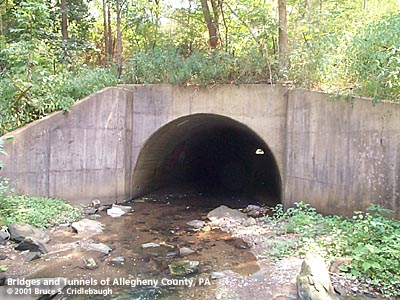
View east More detail photos OFFICIAL NAME: OTHER DESIGNATION: Parkway East over Chalfant Run LOCATION: Churchill USGS 7.5" Topo Quad - UTM Coordinates: Braddock - Zone 17; 0599 4477 CARRIES: Chalfant Run BETWEEN: -- Churchill Valley Country Club, McCrady Rd; -- Duff Run, Rodi Rd UNDER: Penn Lincoln Parkway East (6 lanes); embankment with approx. 100 ft deep fill TYPE OF CONSTRUCTION / DESIGN: horseshoe profile concrete culvert; asphalt floor TOTAL LENGTH: -- 250 ft est OTHER DIMENSIONS: 10 ft est high 10 ft est wide YEAR ERECTED / ENGINEER: 1961, PA Dept of Highways ADDITIONAL INFO: In terms of engineering or aesthetics, this is one of the least significant structures along the Parkway East. It is one of the few exposed culverts large enough to walk through, but the slimy coating of sewage added to Chalfant Run offers no enticement. And though there is a park shelter and walking trails in the Churchill park here, the area is largely ignored. Upstream to the west, the Churchill Valley Country Club occupies the wider part of the valley floor. And here where the Parkway crosses the Run, one's imagination has to take over to consider the valley before the highways. There are traces of the two-century-old Northern Turnpike, three courses of the William Penn Highway (1924, 1941, 1957), the Penn Lincoln Parkway's 1952 western terminus and its 1962 extension. It was the 1962 extension which created the embankment over 100 feet high and some 1500 feet long between the Wilkins and Penn Hills exits. Each successive layer of roads through the valley at the junction of Duff Run from Penn Hills with Chalfant Run heading to Turtle Creek has never completely obliterated what has come before. The projects were always larger in scope and in earth moved, but traces of each remain: a building foundation, bits of dead end concrete roadways, a fallen concrete arch span, a graded roadbed, short simple span bridges -- all hidden in the vegetation that reclaims what's ignored. Just after 1800, the surveyors' original plans for Northern Turnpike would have had the route follow Chalfant Run westward -- maintaining an easier water grade heading west toward Pittsburgh. But historians say William McCrea, who owned property at the crest of Lime Hill (Churchill) and operated a lime kiln there, lobbied to have the route veer south to climb the hill toward his works. Thirty years later, the historic landmark Beulah Presbyterian Church was built along the old pike, across from McCrea's Dundee Farm (former Westinghouse R&D). The Henry Chalfant family is noted in several histories of the region. He was the sixth generation of Chalfant pioneers in Pennsylvania. "Soon after his settlement in Turtle Creek [1827] he became what might be called the Potentate of the valley, for he was the owner of the general store (the market center of a large territory), the Postmaster of one of the early established post-offices of the western country, and was also the proprieter of the long established log tavern, inn, hostel, -- call it what you will, -- with a reputation of high standing. The relay and ticket station for the Pittsburgh and Philadelphia stage-coach line [Greensburg Pike] was also at this inn." Most of eastern Allegheny County which was not within the city limits of Pittsburgh was once Wilkins Township. Only a small part of the township remains; in 1914, 52 citizens of Wilkins petitioned to incorporate as the Village of Chalfant. Chalfant Borough -- at 1/6 mile in land area one of the smallest divisions in the county -- is located just south of the site of Henry Chalfant's home (Greensburg Pike at Marion Av). FIELD CHECKED: 10-Aug-2001 INFO SOURCES: Annals of Old Wilkinsburg and vicinity : the village, 1788-1888 / compiled by the Group for Historical Research, Wilkinsburg, edited by Elizabeth M. Davison and Ellen B. McKee; municipal websites Submit info or inquiry - share some facts or ask a question. Introduction -- Nearby Structures Page created: Last modified: 27-Aug-2001 |
View Larger Map 
| |
| copyright: © Bruce S. Cridlebaugh 1999-2008 All Rights Reserved | |||