| Home > All By Location regional map > Braddock > Dookers Hollow Bridge -- Bell Av | |||
|
|
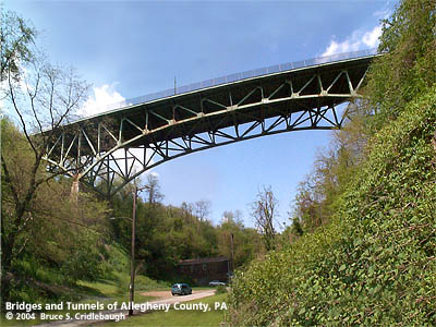
View northwest More detail photos OFFICIAL NAME: Dooker's Hollow Bridge OTHER DESIGNATION: Center Av #4 Bell Av over Dooker's Hollow brad597-16 LOCATION: North Braddock USGS 7.5" Topo Quad - UTM Coordinates: Braddock - Zone 17; 0597 4472 CARRIES: Bell Av / Center Av BETWEEN: -- Bell Av (North Braddock) -- Center Av (East Pittsburgh) CROSSES: -- Dooker's Hollow; O'Connell Blvd TYPE OF CONSTRUCTION / DESIGN: Steel spandrel-braced deck arch (cantilever) LENGTH OF MAIN SPAN: TOTAL LENGTH (including longest elevated ramp): 641 ft HEIGHT OF DECK: YEAR ERECTED / ENGINEER: 1940, Allegheny County ADDITIONAL INFO: The 1903 Hopkins map shows the bottom of Dooker's Hollow divided as the John Dalzell Plan surrounded by land owned by Carnegie Steel Co. Limited. Carnegie built the Edgar Thomson steel works on Braddock's Field along the right bank of the Monongahela River -- immediately south of the opening of Dooker's Hollow. The stream which formed Dooker's Hollow flows into Turtle Creek within the steel works, but has been long ago covered over. "Dook" is a Scots word (sounds like "duke") for swimming ("dookers" is a swimsuit) and presumably in the ravine above Andrew Carnegie's steel works the local folk found the stream good for "dooking." The same map shows Bell Av as Township Road in Braddock. A "High Bridge," constructed by the street railway, connected Township Road via Keller Rd and Terrace St to Bessemer Av in East Pittsburgh. Some remnants of the earlier course of this crossing are still evident. A metal builder's plaque is attached to a stone pylon at each end of the bridge:
FIELD CHECKED: INFO SOURCES: field check Submit info or inquiry - share some facts or ask a question. Introduction -- Nearby Structures Page created: Last modified: 7-May-2003 |
View Larger Map 
| |
| copyright: © Bruce S. Cridlebaugh 1999-2008 All Rights Reserved | |||