| Home > All By Location regional map > Braddock > Parkway East Interchange - Greensburg Pike | |||
|
|
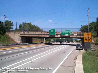
View east More detail photos OFFICIAL NAME: Penn Lincoln Parkway East - Interchange 12 - Greensburg Pike [mileage-based interchange # 9] Greensburg Pike Interchange SR8014 OTHER DESIGNATION: LOCATION: Churchill USGS 7.5" Topo Quad - UTM Coordinates: Braddock - Zone 17; 0596 4477 CARRIES: -- Greensburg Pike (4 lanes) Interchange includes: -- eastbound exit from Parkway East [I-376, US22] to Greensburg Pike -- westbound entrance to Parkway East [I-376, US22] from Old William Penn Hwy BETWEEN: CROSSES: -- Parkway East mainline (5 lanes, plus exit lane) TYPE OF CONSTRUCTION / DESIGN: steel girder, outer girders faced with concrete abutments faced with broken rangework standstone LENGTH OF MAIN SPAN: 173 ft TOTAL LENGTH (including longest elevated ramp): 173 ft HEIGHT OF DECK: -- 14ft 1 in posted clearance in exit lane YEAR ERECTED / ENGINEER: 1952 (replaced c198x), PA Dept of Highways ADDITIONAL INFO: This is the second bridge to carry Greensburg Pike over the Parkway East. The original bridge was a concrete rigid frame segmental arch faced with sandstone in a broken rangework design. The bridge had a span of 98 feet and crossed four lanes of the highway. But standing at the top of a 2.5 mile incline which begins at the Braddock Av interchange in Edgewood and continues at grades up to 5 percent, the bridge marked the crest of a challenge for eastbound truck traffic. An eastbound climbing lane was added from a point just east of Chestnut St in Edgewood to merge just beyond Greensburg Pike. The third lane was able to fit within the constraints of most of the structures although some changes were needed: additional stringers on the overpass at the WB Wilkinsburg exit and large concrete retaining wall approaching Greensburg Pike eastbound. But the original bridge carrying Greensburg Pike was too short and, being a concrete rigid frame, it could not be altered. The newer structure is a steel girder simple span. The outer girders have a coating of concrete to blend with the masonry abutments. The deck carries four lanes of Greensburg Pike. The present bridge shares the sandstone facing of its predecessor. Within months after the completion of the bridge, vandals painted graffitti on the east side of the northern abutment. They were soon caught, made restitution and the sandstone was cleaned. The path of Greensburg Pike follows a ridgeline from Turtle Creek to the hilltop between Wilkinsburg and Churchill. Many Indians paths followed the ridgelines to avoid the swampy lowlands and this was one of two branches of the Raystown Path from Bedford. General John Forbes used the northern branch (Frankstown Rd) in 1758 when he took over the site of what would become Pittsburgh. General Edward Braddock followed the Nemacolin's Path before meeting his defeat as he advanced toward the Forks of the Ohio in 1755. The portion of Greensburg Pike between Circleville and Churchill linked those two important early roads and became probably the most important east-west route across Pennsylvania. On Lime Hill, one of the highest hilltops in Allegheny County, the Greensburg Pike and the Northern Turnpike met. This site has been noted as the location of one of several places called "Bullock Pens." Local historians say the pens were an important source of livestock for the military forces in early Pittsburgh. The Forbes and Braddock Roads had been built as military roads. The routes suited their purposes, but over time, the State Road modified the route from the east. An 1806 act authorized a new turnpike to be constructed, with commisioners in the various counties along its route. Dividing the routes into section made fundraising by stock subscription easier. An 1811 act authorized the commonwealth to provide $300,000 to the company which could raise $150,000 in stock. A competition developed between the southern route (which included the Greensburg Pike) and what would become the Northern Turnpike. The rivalry delayed the construction of both, with the Northern Pike opening locally in 1819 -- after the southern route. The section of the southern route known as The Pittsburgh and Greensburg Turnpike was promoted by Westmoreland County Associate Justice Colonel John Irwin. In 1814 the road was opened "past the Colonel's home on Brush Hill Road in Irwin, as well as his brother's house on Verdant Drive" and westward to Turtle Creek. By 1820, the toll road was expanded to reach from Philadelphia (roughly along the line of today's US30 - Lincoln Highway) to Pittsburgh along Penn Av. Dates found in various sources indicate that the construction in Western Pennsylvania progressed from west to east. William Wilkins, judge and namesake of the nearby town and township, was president of the Pittsburgh and Greensburg Turnpike Company. Managers included other prominent citizens: William Carver, William B. Foster (father of songwriter Stephen Collins Foster), William Fullerton, William Hindman, James Irwin, Abraham Horbach, Dunning McNair (part of early Wilkinsburg was once McNairstown), Jacob Negley Jr., Tobias Painter, Ephraim Pentland (newspaper publisher and politician), Robert Patterson and Thomas Simpson. An important criminal case in this county is related to the construction of the Greensburg Pike nearby. A history published by the Allegheny County Centennial Committee notes that the second person convicted of murder and executed in Allegheny County was John Tiernan. The victim, Patrick Campbell was a contractor on the Pittsburgh and Greensburg Turnpike and was living in a cabin north of Turtle Creek. In December 1817, Tiernan was boarding with Campbell while employed as a laborer for the Turnpike Company. He killed Campbell with an axe, robbed him and fled to Pittsburgh on the victim's horse. Tiernan was soon captured, convicted in January, 1818, and executed on Boyd's Hill. Wilkins respresented the commonwealth in the trial. It was reported this was the second of only three public executions in Allegheny County's history. FIELD CHECKED: 02-Aug-2001 INFO SOURCES: fieldcheck; PA Dept of Highways, "Penn Lincoln Parkway", 1953; PA Turnpike "Traveler"; Swetnam & Smith "Guidebook to Historic Western PA"; Allegheny County Centennial Committee history, 1888; Collins, "Stringtown on the Pike"; Boucher, "Old and New Westmoreland", 1918 Submit info or inquiry - share some facts or ask a question. Introduction -- Nearby Structures Page created: Last modified: 09-Aug-2001 |
View Larger Map View Larger Map 
| |
| copyright: © Bruce S. Cridlebaugh 1999-2008 All Rights Reserved | |||