
| |||
| Home > All By Location regional map > Ambridge > Coraopolis - Neville Island Bridge | |||
|
|
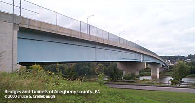
View toward Neville Island on downstream side OFFICIAL NAME: OTHER DESIGNATION: Coraopolis - Neville Island Bridge OB02 [Ohio River Back Channel Bridge No. 2] ambr571-18 LOCATION: Coraopolis - Neville Twp USGS 7.5" Topo Quad - UTM Coordinates: Ambridge - Zone 17; 0571 4485 CARRIES: BETWEEN: -- Grand Av (Neville Twp) -- Fourth Av [PA51]; Ferree St (Coraopolis) CROSSES: -- Ohio River back channel at Mile 9.6 -- CSX RR [PLE RR] TYPE OF CONSTRUCTION / DESIGN: steel deck girder LENGTH OF MAIN SPAN: 199 ft est TOTAL LENGTH (including longest elevated ramp): HEIGHT OF DECK: 45 ft est Dashields Dam normal pool level 692.0 ft YEAR ERECTED / ENGINEER: 1994-95 County of Allegheny Herbert C. Higgenbotham, II; Director, Department of Engineering and Construction Joseph P. Moses; Director, Department of Special Services and Maintenance Operations Commisioners, 1992-1995: Tom Foerster, Chairman Pete Flaherty Larry Dunn ADDITIONAL INFO: Third bridge at this location. The first bridge was one of two built at each end of Neville Island in 1894 to allow a streetcar connection to the mainland. It was one of only four toll bridges remaining when the County proposed to purchase and replace it. The old Sixth Street Bridge from downtown Pittsburgh was partially dismantled, floated downstream on pontoons and re-erected in this location in 1927. The current bridge replaced that older bridge which was typically closed during cold weather. Neville Island was previously named Montour's Island for an Native American who once lived in the area. The name also appear on many other locations nearby including Montour Run which enters the Ohio River just upstream from this bridge. The 1000 acre island was given to General John Neville of the American Army during the Revolution. His primary residences were at Woodville on Chartiers Creek (given to his son Pressley and now preserved as a national historic landmark), and nearby his Bower Hill mansion which was burned in 1794 during the Whiskey Rebellion. General Neville died on the island in 1803 and was buried in the Trinity churchyard in downtown Pittsburgh. The island was deeded to his only daughter Amelia, who with her husband, Captain Issac Craig of the Revolutionary Army, lived on the island. It has been known as Hamilton's Island and Long Island. It is about 5 miles long and averages 3/8 mile wide. The island was once a lush, tree-covered haven with about 40 small farms. In the 1890's, Pittsburgh, Neville Island and Coraopolis Railway proposed to sell the island property for manufacturing. The plan was defeated but at least one-third of the area was given over for ship building and other industry. The U.S. Government took over much of the property through eminent domain for use in manufacturing of heavy guns and as an arsenal for the First World War. Once this purpose had been served, the land was auctioned off. This led to the current state of the island being largely manufacturing, including steel finishing and chemical plants. The upstream end of the island is especially dense in industry, with the exception of a tiny cemetery hidden next to the main channel of the Ohio River. The downstream portion, roughly from the Interstate 79 bridge west, is residential -- much of it having built as housing for the wartime employees during the Second World War. The island has been plagued with the remains of its industrial past. Many places are tainted with chemical pollutants, including the Coraopolis - Neville Island Bridge site, which was part of an EPA SuperFund cleanup project. The adjacent land has since been reclaimed as part of a large sports and recreation facility. FIELD CHECKED: INFO SOURCES: Builder plate; Cushing, Thomas. "History of Allegheny County, PA." 1889; Madison, Wis., Northwestern Historical Association, "Memoirs of Allegheny County, Pennsylvania; personal and genealogical. Vol. 1", 1904; Maurey, Edward B. "Where the West began; a story of Coraopolis and the Ohio Valley," 1930. Submit info or inquiry - share some facts or ask a question. Introduction -- Nearby Structures Page created: 29-Oct-2002 Last modified: 29-Oct-2002 |
View Larger Map View Larger Map 
| |
| copyright: © Bruce S. Cridlebaugh 1999-2008 All Rights Reserved | |||