
| |||
| Home > All By Location regional map > Ambridge > Neville Island - Corapolis Bridge 1894-1927 | |||
|
|
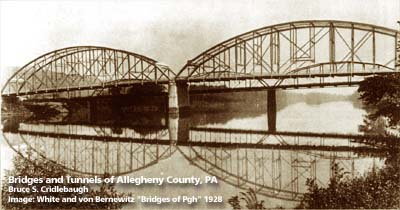
1928 photo with 1894 Neville Island - Coraopolis Bridge in background 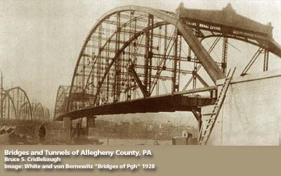
Re-erecting Pittsburgh's 6th Street bridge at Coraopolis with 1894 bridge at left OFFICIAL NAME: OTHER DESIGNATION: Coraopolis Bridge Neville Island - Coraopolis Bridge ambr571-18x LOCATION: Coraopolis - Neville Twp USGS 7.5" Topo Quad - UTM Coordinates: Ambridge - Zone 17; 0571 4485 CARRIES: BETWEEN: -- Grand Av (Neville Twp) -- [PA51] (Coraopolis) CROSSES: -- Ohio River back channel at Mile 9.6 -- CSX RR [PLE RR] TYPE OF CONSTRUCTION / DESIGN: steel through truss, two spans LENGTH OF MAIN SPAN: TOTAL LENGTH (including longest elevated ramp): HEIGHT OF DECK: YEAR ERECTED / ENGINEER: 1894 ADDITIONAL INFO: The first bridge (1894-1927) was one of two built to allow a streetcar connection between Coraopolis (Middletown) and Pittsburgh via Neville Island (Montour Island). The 1894 bridge appears in the background of the top photo and to the left in the lower photo. Curiously, the 1894 bridge was replaced in 1927-8 by an older structure. The Sixth Street Bridge structure from downtown Pittsburgh was constructed two years earlier. In its original downtown location, it joined St. Clair St (Sixth St, downtown) and Federal St (North Side) from 1892-1927. It was partially dismantled and re-erected in this location, just downstream of the previous bridge. Historic American Engineeering Record (HAER): view page - Coraopolis Bridge 1892-1927; Sixth St Bridge 1927-1994 (HAER PA-217); P.A.C. Spero & Company, 1989 FIELD CHECKED: INFO SOURCES: Submit info or inquiry - share some facts or ask a question. Introduction -- Nearby Structures Page created: 22-Jan-2008 Last modified: 22-Jan-2008 |
View Larger Map 
| |
| copyright: © Bruce S. Cridlebaugh 1999-2008 All Rights Reserved | |||