
| |||
| Home > All By Location regional map > Ambridge > Sewickley Bridge 1981 | |||
|
|
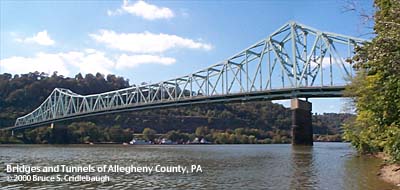
View west from right bank More detail photos OFFICIAL NAME: Sewickley Bridge OTHER DESIGNATION: ambr568-14 LOCATION: Moon Twp - Sewickley USGS 7.5" Topo Quad - UTM Coordinates: Ambridge - Zone 17; 0568 4487 CARRIES: SR4025; Orange Belt BETWEEN: -- Ohio River Blvd [PA65] at Broad St (Sewickley) -- Justice Michael A. Musmanno Memorial Boulevard [PA51] CROSSES: -- Chadwick Av; NS RR [Conrail] -- Ohio River at Mile 11.8 -- CSX RR [PLE RR] TYPE OF CONSTRUCTION / DESIGN: steel cantilever Warren through truss LENGTH OF MAIN SPAN: 724.0 ft TOTAL LENGTH (including longest elevated ramp): HEIGHT OF DECK: 73.4 ft for center 500 ft of channel span Dashields Dam normal pool level 692.0 ft YEAR ERECTED / ENGINEER: 1981; Richardson, Gordon and Associates, Inc. PennDOT, current owner ADDITIONAL INFO: view page - More info on the 1911 Sewickley Bridge over the Ohio River view page - Fieldnotes on the 1981 Sewickley Bridge over the Ohio River view page - Pittsburgh Press article on the 1911 Sewickley Bridge over the Ohio River view page - Coraopolis Record and the Sewickley Herald article on the 1981 Sewickley Bridge over the Ohio River view page - Coraopolis Record and the Sewickley Herald article on the designer of the 1981 Sewickley Bridge over the Ohio River FIELD CHECKED: INFO SOURCES: USACE Ohio River Nav. Charts Submit info or inquiry - share some facts or ask a question. Introduction -- Nearby Structures Page created: 30-Nov-2000 Last modified: 30-Nov-2000 |
View Larger Map View Larger Map 
| |
| copyright: © Bruce S. Cridlebaugh 1999-2008 All Rights Reserved | |||