| Home > All By Location regional map > Freeport > Old Mill Rd over Little Bull Creek | |||
|
|
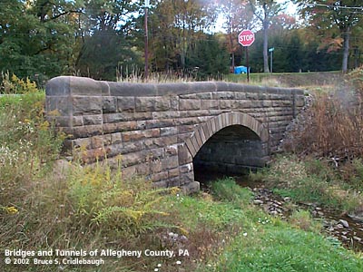
Northern arch wall (upstream right) More detail photos OFFICIAL NAME: OTHER DESIGNATION: Old Mill Rd over Little Bull Creek Millerstown and Freeport Rd, Old Mill Rd, Old PA908, over Little Bull Creek free606-1 LOCATION: Fawn USGS 7.5" Topo Quad - UTM Coordinates: Freeport - Zone 17; 0606 4502 CARRIES: -- Millerstown and Freeport Rd [Old PA908, SR1028] -- Old Mill Rd [T701] BETWEEN: CROSSES: -- Little Bull Creek TYPE OF CONSTRUCTION / DESIGN: northern section carrying Old Mill Rd: stone arch locally-quarried sandstone outer spandrel wall: rock-faced coursed ashlar upper walls and parapets: dressed coursed ashlar arch ring: dressed voussoirs in segmental arch southern section carrying Millerstown and Freeport Rd: concrete and brick rigid frame LENGTH OF MAIN SPAN: 17 ft TOTAL LENGTH (including longest elevated ramp): HEIGHT OF DECK: YEAR ERECTED / ENGINEER: c1900, Allegheny County Charles Davis, County Engineer ADDITIONAL INFO: During years surrounding 1900, Allegheny County, under the direction of County Engineer Charles Davis, was busy throughout the county building stone arch bridges of a simple and similar design. This bridge exhibits the more common design features of the County's stone bridges. The design and construction details match many others still standing elsewhere in the county. The 1876 Hopkins "Atlas of Allegheny County" does not show the section of Millerstown and Freeport Rd between the bridge at Old Mill Rd and Ekastown Rd. All traffic would have crossed Little Bull Creek by this stone bridge. Some time later, the road was straightened to bypass the crossroads at Old Mill and Ekastown roads. The old stone bridge was widened southward with the addition of a concrete and brick rigid frame span which more than doubled the original width. This is partly due to the fact that the new road was extended from the middle of the bridge, thus creating a Y-intersection directly on top of the bridge location. The improved road was formerly designated as PA 908. There are some indications of the old route number on nearby roads, but not on this portion. FIELD CHECKED: 13-Oct-2002 INFO SOURCES: field check; 1876 Hopkins atlas Submit info or inquiry - share some facts or ask a question. Introduction -- Nearby Structures Page created: Last modified: 19-Feb-2003 |
View Larger Map 
| |
| copyright: © Bruce S. Cridlebaugh 1999-2008 All Rights Reserved | |||