| |||
|
|
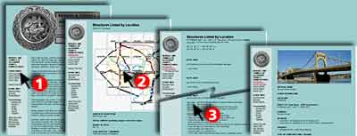
Once a flat sea floor, millions of years of erosion have carved the surface of Allegheny County into a maze of ridges and valleys. Pittsburgh sits where the Monongahela River from the south, and the Allegheny River from the north, join to form the Ohio. Many named and unnamed tributaries steadily cut through layers of sedimentary rock: limestone, sandstone, shale, coal. Today as one stands atop one of the many hilltops above 1,200 feet, it is not difficult to imagine that they were all part of a single, vast plateau, sloping ever so gently down toward the northwest. Pittsburgh and its suburbs are known for steep hillsides covered with buildings, streets which have steps for sidewalks, and sidewalks which are named streets. From the highest point in Allegheny County, 1,401 feet at River Hill in Forward Township, to the 710 foot normal pool level of the Ohio River at the Point in Pittsburgh, and down to the 682 foot elevation on the banks of the Ohio as it exits the County in the west, the elevation varies by a bit more than 700 feet. Other locations may have greater relief, but they are not as heavily urbanized; other cities may be more densely built, but they will tend to be on gentler terrain. With topography such as this, it is not surprising that there are so many bridges. One count reports over 2,000 bridges of 8 feet span or greater. Most types of bridges are represented in this area with the exception of cable-stayed, pontoon, or movable deck designs. Bridge engineers hold their conventions here. The Gateway Clipper Fleet offers guided riverboat tours featuring the bridges. It's virtually impossible to travel any notable distance without crossing a bridge. Long ago, indian trails crossed the area, often following the tops of the ridges to avoid any stream crossings. But with the European conquest and settlement, and nearly simultaneous start of road-building, it was not long before stream fording was replaced by the first simple bridges in the area. In fact, commenting on the British General Braddock's march to the Point in 1755, Colonel George Washington remarked: "instead of pushing on with vigor...they were halting to level every mole-hill and to erect bridges over every brook, by which means we were four days in getting twelve miles." Mount Washington, formerly Coal Hill, rises over 400 feet above the Monongahela River opposite downtown Pittsburgh. This and other ridges and hills were once tunneled into for coal. Now they are tunneled through for transportation. This site seeks to document the "City (and County) of Bridges (and Tunnels)." Where to start with up to 2,000 possible choices? The website is being built to show the most notable structures first -- with the rest to come over time. The Tours, gather these most important structures into logical groups. And "What's New" shows the latest additions. The Overview Map plots the structures on Google Maps.  To choose from a comprehensive listing of structures, (1) go to List by Location, (2) choose a map area, then (3) select from the list for structures in that area. Many significant structures are also listed for quick access; go to List by Design, List by Name, or List by Use. Submit info or inquiry - share some facts or ask a question.
Page created:
02-Feb-1999
|

| |
| copyright: © Bruce S. Cridlebaugh 1999-2018 All Rights Reserved | |||